
Fiddle Range Traverse
A challenging skywalk along Jasper's eastern edge.
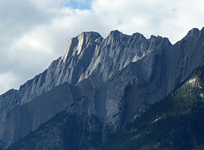
Above: Deep synclines scar the northeast face of an unnamed highpoint between Roche a Perdrix and Fiddle Peak
June 22, 2013 / minute read( words)
Along with nearby Roche Miette, Roche a Perdrix is one of the most distinctive peaks one sees as they near Jasper National Park from Hinton, and it had been on my list of to-dos for quite some time. While the mountain sat in my waiting list a number of posters at Clubtread began discussing the feasibility of traversing an intimidating looking ridge south from the summit of Perdrix towards Fiddle Peak, the tallest mountain in the Fiddle Range. This struck me as an interesting possibility, so I kept my eyes on the discussion.
A year later a poster at that forum (Semi-Awesome) documented a successful traverse from Perdrix to Fiddle, and it simply became a matter of when I would attempt to do the same trip. When a heavy (and eventually devastating) storm system turned me away from plans in Kananaskis towards a sunnier forecast in Jasper, I found myself at the foot of Perdrix at 8 am in the morning, having left Edmonton at a rather disgusting time of 4 am.
The attempt would result in a hard and technically challenging 10-hour solo trip with 2,328m of accumulated elevation gain, but it was a success! The only day trips I have that can top that are White Pyramid, and an epic poem voyage Steven and I did in Skoki last summer, both of which are trips that I have shamefully failed to write about yet! Despite the difficulty, which was compounded by me running out of water on the return (having started with 3 litres), it was an incredibly rewarding day in the mountains.
Routefinding
It should be said that, on its own, Roche a Perdrix can be a reasonably easy scramble for anyone with route finding experience. Everything described beyond that point, however, should only be tackled by experienced scramblers comfortable with difficult, exposed terrain. Fiddle Peak on its own is an easy ascent from almost all directions, and a few alternative approaches will be discussed in the Considerations section.
The trailhead for Roche a Perdrix can be found a few hundred metres east of the main gates for Jasper National Park on the Yellowhead Trail (Hwy 16). If you use the street view in the Google map at the bottom of the page, you'll see a roadside pullout right next to a dirt road leading to the base of the ascent ridge. You can either park on the pullout, or follow the road into an area with parking spots and a turnaround.
The ascent trail begins to the climber's right of that ridge and will lead you gently up the side of Perdrix and past a colourful assortment of wildflowers. Once the trail starts to become rather vague in direction you'll want to ascend to the top of the ridge and then follow it towards two distinctive 'bumps.' Chances are that you'll top out very near the first of the two bumps, which can easily be ascended by following a defined trail to the climber's left (which sneaks through a few trees before depositing you back on the grassy ridgetop). From there, simply hike up the ridge towards the second bump.
Although the route was recorded with a GPS unit, this data should only be used as a SECONDARY navigation tool.
Near the base of the second bump, you should see a rock cairn to the climber's left, and a trail beyond it which heads through forest around to the eastern face of Perdrix. The hike through the forest can be a bit 'spider-webby,' so make sure you're not the lead person in your group ;-). After ten minutes you'll emerge from the forest to begin a long traverse below the cliffs of Perdrix. At this point, take a moment to put your helmet on, and then keep moving along the packed scree trail until you reach the safety of the ascent gullies on the east side of the mountain (rockfall is a significant risk here).
What follows is sort of a diagonal ascent of three parallel gullies, where you'll follow a gully up, traverse over to the next one, ascend, traverse, and then ascend once again until you're looking at a sharp turn up the final slopes to the summit ridge. This whole stretch has defined trails and cairns, so it's not difficult to follow.
Take note of the streams in these gullies as they're the only water sources you'll see along this trip. Also note that they are likely to be completely dry by August, if not sooner.

The slopes leading to the summit ridge are best tackled by following a worn trail to the treeline before difficult slab sections will force you to drift to the climber's right to pursue easier lines of ascent.
When you finally crest the summit ridge take careful note of where you came up. There are a lot of useless cairns in this area of the mountain that, upon my return, kept leading me to needlessly risky descent lines (such as 5-6m downsloping slabs offering only friction holds). I found myself repeatedly having to make exposed traverses to find easier lines far to the skier's left. If you forget where you came up, at least remember not to cut down early into areas you purposely avoided on the way up.
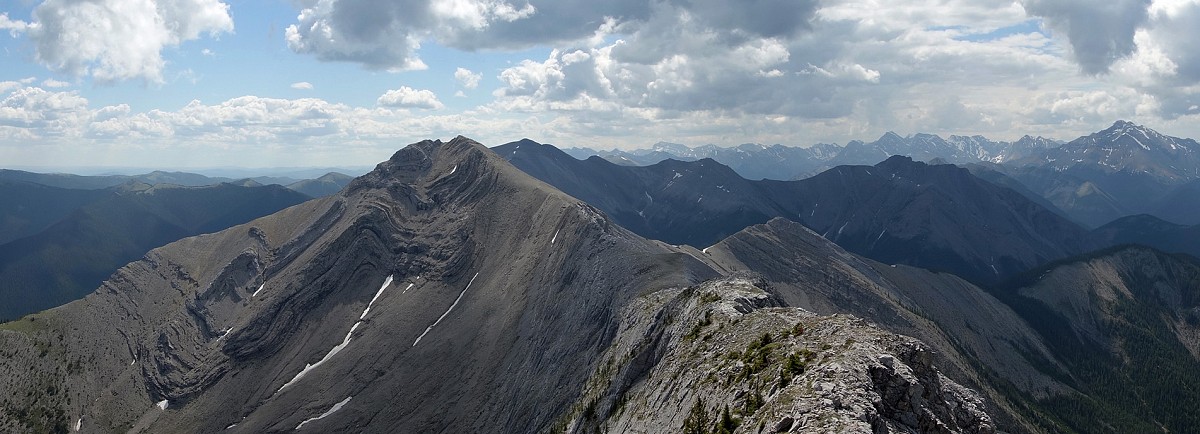
Once you've reached the summit ridge, it's an easy 5-minute hike to the summit cairns of Roche a Perdrix, and a great view of the intimidating ridge that awaits those contemplating the traverse to Fiddle Peak.
The Traverse
The traverse to Fiddle Peak begins with an easy ridgewalk to the first of two significant highpoints. Upon arriving at the first highpoint, you will want to head up an open scree slope to the climber's left and then follow it all the to a rocky outcrop that can be scrambled. From the top of those rocks, you should see a well-defined crack in a slab wall leading back towards the main gully to the climber's right. This crack offers good holds as you ascend diagonally, but you'll want to be careful while traversing here due to the 5m drop to which you'll be exposed.
One you've reached the main gully on this highpoint you'll want to head diagonally up to the climber's right to ascend a slabby slope that leads to the top. While climbing this slope is not a problem, the spaced-out, shallow holds it offers make for a challenging descent in dry conditions.
While the first highpoint isn't as bad as it looks, the second one certainly is. After a relaxing ridgewalk from the first highpoint, you'll run into a pair of 3m tall, vertical rock bands that prevent an easy ascent of the second highpoint. Thankfully detour options exist. Unfortunately, they all involve significant risk.

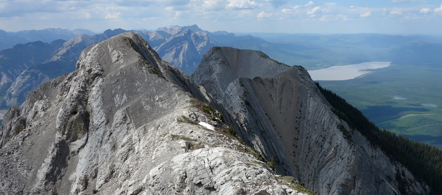
After exploring the area for a number of minutes, I decided that my best move would be to detour to the climber's left to gain the 6m I needed on a steep slope with a lot of mossy patches. The east side of the mountain at this point is seriously steep and remains so all the way down to the valley below. Every rock I dislodged would bound 200-300m down the mountain before falling out of sight, at which point its progress would remain audible for several seconds more. Between some loose rock and moss-covered steps which could conceal anything, I had to test every hold before committing and move very methodically; this wasn't a happy place to be, and I was relieved to get past it. Once you've reached the top of that second 3m rockband, it's an easy scramble to the highpoint of the Fiddle traverse at 2,244m (7,362 ft).
An easy ascent/descent route for the second highpoint may exist in the form a slabby ramp that's further around the east side of the mountain. Although I never used it, it was my “Plan B” both times I came through the area (see image 42). Getting to and from this ramp would involve some sketchy side-sloping from the ridge (connecting H1 and H2) to its base, but you would at least be protected from some of the exposure while on it. I couldn't really gauge how steep it might be.
It's important to note that if there is any significant precipitation after this point during your trip, do not return this way. Descending either highpoint in wet conditions would be too dangerous, so you would want to exit via Folding Mountain.
After a pleasant hiking section the ridge connecting the second highpoint to an unnamed, but cool looking mountain to the south narrows considerably and provides a few exposed, technical steps to keep you on your toes. This ridge terminates in a crack traverse that'll be very reminiscent to the one back at the first highpoint, with the added challenge of having a small tree growing in it that you need to brush past.
What follows is what I dubbed the 'big bypass.' You could easily summit this unnamed peak, but due to time on the way out, and energy preservation on the way back, I simply chose to bypass it following a game trail on the west side. It may appear at points that you'll be faced with a large elevation loss and regain for Fiddle Peak, but that's thankfully not the case. Once you've hiked around the mountain, you'll be faced with an easy scramble up the north slopes of Fiddle, and to a registry with only a handful of names in it.
The return trip involves retracing one's steps all the way back to the trailhead, with the only real exception for me being the downclimbing route I chose on the second highpoint. I took a much more direct route, first descending to the lowest point of the second rock band. From there I used a solid handhold with my left hand and a good platform to plant my left foot to secure myself, and then I swung around like a door hinge to the left and before making a small jump to the rockband below (refer to images 44 & 45). This worked quite well, but I don't believe that this route could be reversed safely for an ascent.
Considerations
If weather conditions change or you don't feel comfortable downclimbing the highpoints of the traverse, the best alternative return route is via Folding Mountain to the east. To get there, you'll want to follow the Fiddle's southeastern ridge from the summit and then descend, climb and bushwhack your way to the summit of Folding Mountain along the connecting ridges. From that summit, follow the open ridge northward until you find the hiking trail that will lead you back to Hwy 16 near the rest stop. From there you will need to hike or hitch a ride a few kilometres westward to return to the trailhead for Roche a Perdrix.
Share this report on:
If the water levels on the Fiddle River permit a safe crossing (likely from August onwards), it may also be possible to head southwest towards the Miette Road or to head south towards the Mystery Lake Trail for a return via Shuey Pass.
Further Reading
The ascent of Roche a Perdrix is also described in Alan Kane's book, Scrambles in the Canadian Rockies (pg.328).


")


")


")