
Opal Peak & Beyond
A fantastic, but largely unknown, ridgewalk.
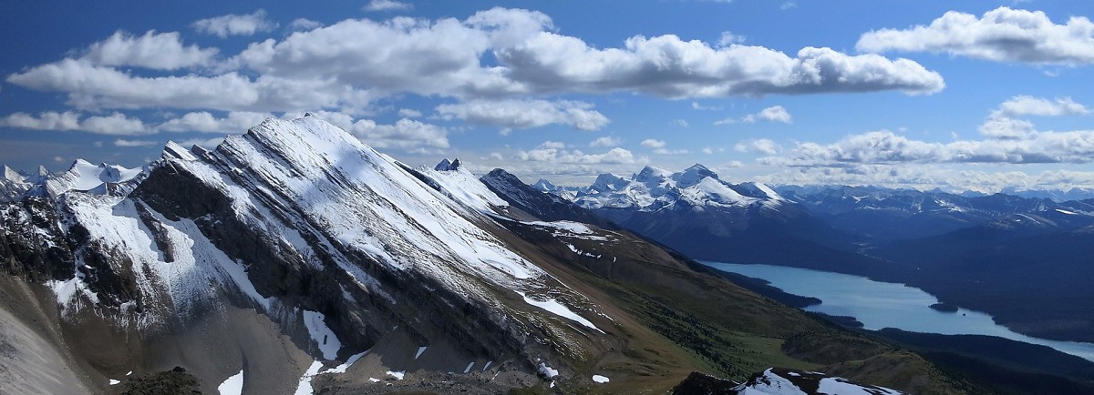
Above: Opal Peak & Maligne Lake from a unnamed ridge to the north.
September 02, 2012 / minute read( words)
Sometimes good things can come from broken plans. I was set to climb Resolute Mountain in the David Thompson area (near Nordegg) with Andrea and Steven the day before when a “thunder-blizzard” (a mix of thunderstorms and significant snowfall at upper elevations) sent the three of us scrambling to different parts of the province in search of Plan B. After spending the night sleeping in the parking lot at Parker Ridge (near the Columbia Icefields) with the idea of climbing Nigel SE3 (a sub-peak of Mt. Nigel that I've had my eye on for a while), I awoke to a sleet storm which sent me scurrying north towards any alternative objective I could conceive.
Given the uncertain weather, I decided to attempt an easier mountain in the Jasper National Park region and soon found myself on the shores of the lovely Maligne Lake, and the beginning of the Opal Hills trail.
Although many people simply hike the rather unremarkable Opal Hills loop and call it a day, those looking to get the most from the area will definitely want to treat the trail as an access point rather than as a proper destination. For the fit and ambitious, what lies beyond Opal's pleasant alpine meadow is a wealth of peaks and open ridges that are (with few exceptions) all walkable, and for several kilometres in each direction. Best of all, those venturing up Opal Peak, or along its broad shoulders, will discover that the valley to its east is perhaps just as spectacular as that to the west.
What had begun as an attempt to salvage anything from a weekend ravaged by a sudden, detrimental change in the weather, turned into one of the best ridgewalks I've ever experienced in the Rockies. A strong wind in the morning made the conditions bitterly cold at times, but this was a fair trade-off for the few inches of fresh snow which brought out the absolute best in the surrounding landscape. This is definitely an area that I'll be returning to for further exploration!
Although the route was recorded with a GPS unit, this data should only be used as a SECONDARY navigation tool.
Routefinding
The trailhead for Opal Hills can be found in the main parking area to the right of the Maligne Lake Chalet, 42km south of the Trans-Canada Highway (Hwy 1) along the Maligne Lake Road. This parking area contains three separate lots, and the one you want is most northeasterly of the three; which you can reach by taking the first left turn, and then following the road around the back.
From the parking area, follow an obvious trail eastward and then take the left path when you reach the Opal Hills/Mary Schaffer Trail junction. The majority of the trail is viewless as you head steadily uphill through the forest for a few kilometres before arriving at the beginning of the loop. In which direction you should do the loop could depend on your ultimate destination, or how you wish to sequence/time your trip. Regardless, the swiftest route to Opal Peak is to follow the trail to the right, which would lead you to do the loop in a counter-clockwise direction (which is what this report describes).
Once you've followed the right trail around a ridge, beyond the treeline, and into the open meadows above, you'll be confronted with a lot of possible choices. You could just follow the loop trail northward, or you can begin to ascend the surrounding hills in almost any direction. If you were to follow my route map exactly, you would end up taking the main trail across a small drainage, and then proceed to follow a faint trail along that drainage which angles towards the col between Opal Peak and an unnamed peak to its immediate south (you should be able to see a diagonal trail leading towards a large cairn). However, my suggestion is to follow the well-worn trail heading up the ridge to the right (seen in this photo) which not only provides a great view of Maligne Lake, but can also be used to access the summit ridge of the peak to the south of Opal.

Although this terrain can be easily walked-up, and the traverse north towards Opal Peak doesn't require any hands-on scrambling, there is a considerable amount of exposure along the east side of the summit ridge which requires some care. That said, you can avoid most of the exposure by simply staying a few metres to the west of the summit crest.
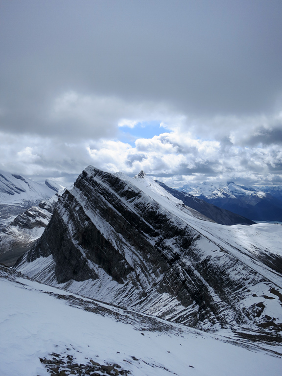
I ascended Opal Peak along its southwest ridge and descended via its northwest ridge (this can be reversed easily depending on your loop direction). Both ridges are easy scree ramps that have well-formed switch-backing trails from frequent use. Even with a few inches of snow and a layer of verglas, I still had no real difficulty reaching Opal's summit. The only cautionary note I have for Opal is the same as for the summit to its immediate south; the ramp you ascend from the west does end rather abruptly at a sheer eastern face, and you can expect there to be a cornice along the eastern edge of the summit for most of the year.
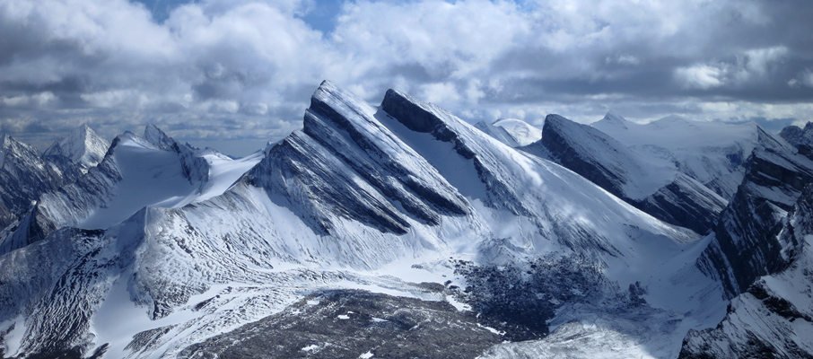
The peak to the immediate north of Opal can easily be walked up along its southwestern ridge, and has a broad, crescent-shaped summit plateau that can be explored quite safely. Both Medicine and Surprise Lakes can be seen from this peak, but the best view is the one towards a beautifully verdant, forested valley, that has a number of tarns and is completely hidden from view by the sprawling arms of the mountain range.
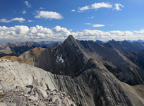
From this unnamed peak, and to my delight, I found that there are two options for continuing the ridgewalk: a northwest ridge that leads towards Medicine Lake, and a northeast ridge which leads towards Surprise Lake. The northwest route looks like it may require some moderately difficult scrambling near its beginning to overcome a narrow climb in the ridge, but beyond that, it should be smooth-sailing for the next kilometre or two leading to an excellent view of Medicine Lake. As for the northeast route, I enjoyed an easy walk over to the next highpoint (seen on the left here) where I was once again presented with two ridges to follow: a northerly ridge heading towards Medicine Lake, and a short, easterly ridge leading to a lookout over Surprise Lake. As I was nearing my turnaround time, I took the east ridge.
The east ridge narrows and becomes an exposed, moderately difficult scramble as you proceed across. If you're not into scrambling, you can bypass this section by dropping about 50-60m down the slope to the left (north) and then side-hilling across the large, loose scree which litters that side before regaining the ridge near its end. Otherwise, my suggestion would be to drop to a shelf a few metres below the ridge crest on the left, and then follow it until about the halfway point of the ridge. At that point, climb back onto the ridge crest (which should now be easier/safer to follow) and then look for a hidden chimney to the left, about 6m back from where the crest suddenly ends, in order to downclimb safely to the last portion of the ridge.
Retrace your steps back along the various ridges to the col between the 2,616m north peak and Opal Peak where, if you traverse towards the Opal Peak descent route, you should find a trail leading you down to the main Opal Hills Loop trail, and then back to the trailhead.

Considerations
Share this report on:
The Opal Hills area is a traditional hotspot for bear activity, and has been the subject of closures on multiple occasions over the past several years. To avoid disappointment, be sure to check out Jasper's bear advisory page before heading out to this area. Even when the area isn't subject of an advisory, carrying bear spray and making plenty of noise along the trail is highly advisable.


