

 July-01-2012
 A popular destination for hikers visiting the Canmore area, Read's Ridge and Read's Tower are outliers of Mt. Sparrowhawk that offer incredibly impressive views of the sprawling Spray Lakes Reservoir, and the dozens of peaks which surround it. Accessed via a steep, but not technically difficult trail, Read's Ridge makes for an excellent hiking or even picnic destination (as I witnessed several people doing on Canada Day), while Read's Tower is an optional extension for those looking for a little more challenge, elevation gain, and improved views.
Trip Information
The trailhead for Read's Ridge can easily be spotted directly across the road from the Sparrowhawk Day-Use Area (southeast from the bathrooms), which in turn, can be reached by travelling 24km south along the Spray Lakes Road from within the Town of Canmore. Note that this road is largely unpaved, and can be quite rough at times.
From the trailhead, follow the path along Sparrowhawk Creek for about a kilometre before reaching a fork marked with a large cairn and a number of trees which seemed to be flagged for future maintenance work. The right fork continues along the creek for several kilometres before reaching the Sparrowhawk Tarns, a pair of ponds near the foot of Mt. Bogart. The left fork will lead you to the beginning of the steep ascent up Read's Ridge.
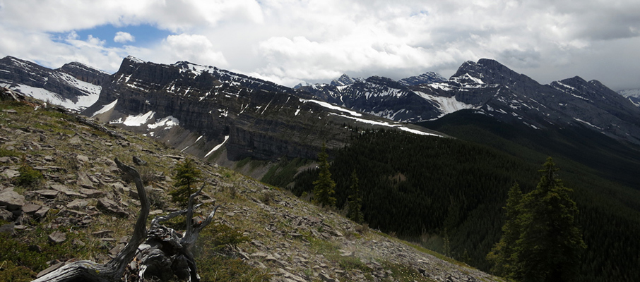
The next portion is a bit of an uphill grind, but you'll gain elevation quickly. Once you top out on the ridge, the rest of the walk leading towards Read's Tower is easy, pleasant, and offers great views. Reaching the Read Ridge “summit” cairn (at an elevation of 2,364m / 7,756 ft.), located near the base of Read's Tower, only took me an hour and twenty minutes from the trailhead. A more reasonable pace should see you there in little more than two hours.
Considerations
There are multiple options available from this junction. The first is to head for the gully between Read's Tower and Mt. Sparrowhawk, which is the traditional scrambling route to the 3,121m / 10,240 ft. peak of that mountain (which I hope to describe in a future trip report). The second is to descend slightly to the climber's right and then begin following the faint trail up Read's Tower to its 2,664m / 8,740 ft. summit (a challenging hike which requires some boulder-hopping). The third option is to bypass Read's Tower by contouring to the climber's right of it and then continuing onwards to the Sparrowhawk Tarns (note: this option requires both route finding skills and scrambling ability). Lastly, you can simply choose to return along the same route to the trailhead to conclude your day. Sparrowhawk had a lot more snow than I was expecting, so I went for the second option and began the ascent of Read's Tower.
Most people follow the existing path and ascend straight up the left (northwestern side) of the ramp-like tower (watch out for the abrupt cliff, mid-way up), which from the beginning is mostly boulder-hopping and incredibly loose scree. However, the further southeast you traverse across the bottom of Read's Tower, the higher the vegetation goes up the ramp, and the vegetation here is much easier to climb. If you take a close look at the route map, you can see where I detoured around the cliff during my ascent, and how I took a very different route for my descent. I'd suggest using my descent route in both directions.
It took me 45 minutes to ascend the 300m between Read's Ridge and the Tower's summit via the traditional route. Keep in mind that the ramp-like Tower ends abruptly at a cliff only a few feet past the summit cairn. When I was on the summit this July, there was still a substantial cornice hanging from its northeastern face.
Once you've filled-up your camera's memory card, enjoyed your victory snack, and gathered up your gear, simply pick the best looking route down the tower, and follow the trail along Read's Ridge (you'll be facing directly towards the best views the entire time on the return) all the way back to the beginning to wrap up your day.
Further Reading
An extended hike covering Read's Ridge, the Sparrowhawk Tarns and nearby Red Ridge is another option covered in Mike Potter's Ridgewalks in the Canadian Rockies.


")


