Roche Bonhomme
Come for the workout, stay for the flowers.
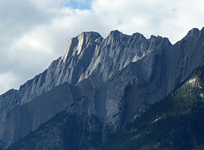
Above: Gazing along the Colin Range towards the Maligne Lake area.
August 03, 2014 / minute read( words)
Roche Bonhomme is a very popular scramble amongst locals in the Town of Jasper (where it's more commonly known as “Old Man”) and a favourite training location for some of its elite athletes. Overlooking the wildly popular Maligne Canyon, the mountain is easily identified from town by a summit ridge to the east whose high points, folds and creases form the unmistakable profile of a native man in full ceremonial headdress. It's an easy scramble technically, and ends with a pleasant ridgewalk, but requires a considerable amount of elevation gain on a steep and direct ascent route.
Roche Bonhomme was a “Plan B” destination for me on this particular August weekend, with a combination of haze and stormy weather diverting me from my original plans in the Tonquin region. Unfortunately, due to those conditions, my photography from the day doesn't do the mountain's views justice, but my report from nearby Hawk Mountain should provide a reasonable expectation for what you may see on a nicer day.
Routefinding
The most difficult part of ascending Roche Bonhomme (from a routefinding aspect at least) is pinpointing the exact location of the trailhead. Heading east from the Town of Jasper on the Yellowhead (Hwy. 16) you'll want to turn off onto the Maligne Road and follow it to the main parking area for Maligne Canyon. I suggest parking reasonably close to the restaurant building here as you'll be walking straight back to the road and then along it to the south.
Although the route was recorded with a GPS unit, this data should only be used as a SECONDARY navigation tool.
Roughly 350m down the road you'll see a large sign with the lake tour schedule on the right (west) side of the road (image #2). A few metres further on the left (east) of this sign you'll find a small cairn and a subtle trail heading up a ditch and into the trees (image #3). This is the trailhead, but it's easy to miss so be sure to look for the sign first.

The rest of the route up the mountain is straight forward along an obvious trail, starting through the forest and past two distinct canyon sections (the first is shallow while the second is noticeably deeper). Nearing the halfway point of the ascent (above the second canyon) you'll pass a much younger section of forest that, aside from ushering a welcome reduction in the trail's steepness for a period, also marks the beginning of a great variety of wildflowers along the route. Given the general lack of views along this trail below treeline, this “macro buffet” (as I came to label it) was much appreciated.
This mellower section of the trail eventually gives way to a long, steep section that climbs to the climber's left of a huge open slab slope which likely has waterfalls running down it during wetter periods of the season. The trail becomes a bit overgrown above this slope, but after bashing your way a bit through the “evergreen carwash” you'll soon reach the treeline and (finally!) open views of the Colin, Maligne, Victoria Cross and Trident mountain ranges and the many lakes which dot the valley floor.

Share this report on:
The transition from forest to scree sees the continuation of an obvious trail, which switchbacks gently amongst a few easy rock steps to the northern end of Bonhomme's summit ridge. From here (the top of the "headdress") an easy ridgewalk with minimal exposure will lead you up and over a few high points (the forehead and nose) before eventually reaching the mountain's true summit at the southern end (the chin). Retrace your route during the long and punishing descent to before wrapping your day up with something delicious back in Jasper.
A cave exists along the summit ridge between the nose and chin. While a great location to seek shelter from heavy winds or rain, it would make a poor choice in a lightning storm. It also appears to be a popular location for recreational herbalists (image #33).


 canyon section")
 canyon section")


, its many lakes and Pyramid Mountain (right) come into view")


")