
Big Bend Peak
A great scrambling viewpoint for the Columbia Icefields.
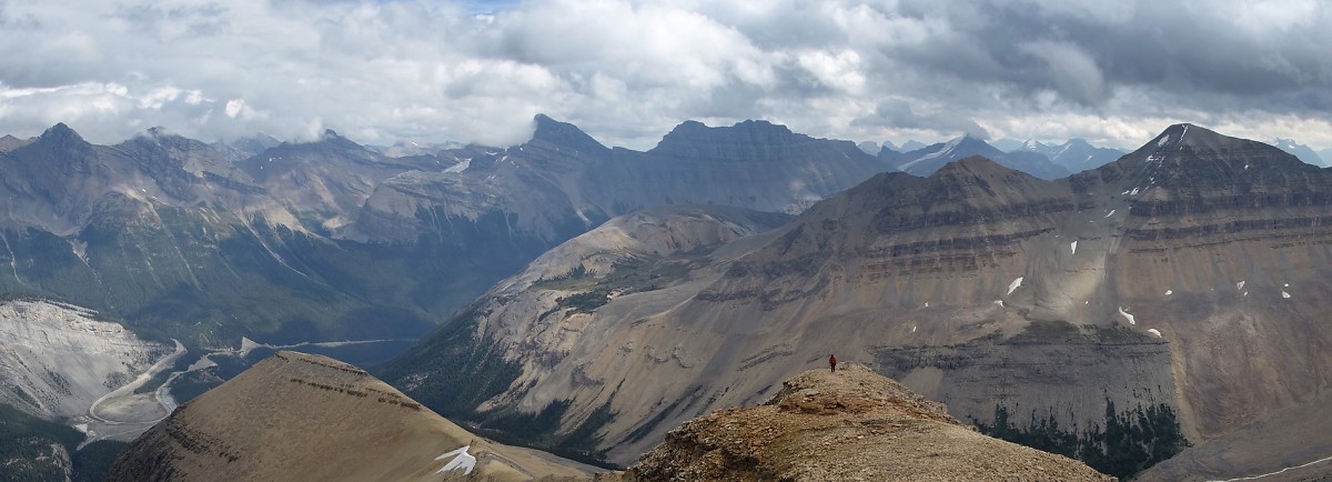
Above: From the beginning to the end on Big Bend Peak
August 24, 2013 / minute read( words)
Unofficially named for the gigantic switchback in the Icefields Parkway near the base of the mountain, Big Bend Peak is a reasonably easy scramble that offers big views of the Columbia Icefields region. Part of a cluster of peaks surrounding Mt. Saskatchewan, one can easily see (weather permitting) dozens of glaciers and giants such as Mt. Bryce, Mt. Columbia, and the heavily glaciated south face of Mt. Andromeda.
As part of my first weekend as an official trip leader for the Edmonton Hikers Group, our group (Aneika, Charlotte, Fabrizio, Kevin, Pierre and myself) encountered increasingly variable weather during our ascent and a dense cloud layer to the west upon reaching the summit. Despite those minor setbacks, it was still an excellent day.
Routefinding
An ascent of Big Bend Peak begins with a quick hike along the Saskatchewan Glacier access trail. To find this trailhead from the north, follow the Icefields Parkway south for 16km from the Icefields Centre to the precipitous drop down the “Big Bend” and look for a small parking area with a bridge (on the right) once you've rounded the big turn at the bottom. If coming from the south (it's 33km north of Saskatchewan River Crossing) I guarantee you'll miss this parking area as it's very well hidden from that direction. If coming from the south, use the large pullout area on the bottom loop of the “Big Bend” to turn around and then look for it on your right.
Although the route was recorded with a GPS unit, this data should only be used as a SECONDARY navigation tool.
From the parking area, the route crosses the bridge and then turns onto a well-used trail several metres further on the right (west). Interestingly the Saskatchewan River completely disappears into an incredibly deep gorge right next to this bridge (don't fall in!). Note that although there is a trail right next to this gorge that continues along the river bed, the main trail is a few metres higher on the top of the bank and is easier to follow.
From there follow the trail along the river and then diagonally (on a northwest heading) across a large field (there were a few cairns along the way) towards a very good trail that leads into (and through) the forest. Nearing the end of the trail you'll reach a huge open slope where the big elevation gain of the day begins.

As seen in image #5, this slope presents two potential routes: the left line's steep but reasonably easy, while the right line's considerably looser and steeper (I'm told it nears 40° at points), but more direct. Due to the experience level of the group and our lack of helmets, we took the easier line.
Regardless of which line you take, the route from the top of the ridge follows game trails to the right (northwest). Follow these trails in that direction until the forest above looks to have thinned out considerably and then easily bushwhack your way to the open meadows and a pleasing hike to the base of Big Bend's pyramidal false summit.
After gaining the first ridge via easy scree slopes we began to contour around the mountain on the climber's left until we had a direct line to ascend that wouldn't require us to break through an obvious cliff band half way up. Unfortunately, this line proved to be treadmill scree all the way to within a few metres of the false summit, but aside from the workout, the line presented no technical difficulties.
It may be worthwhile to contour further to the climber's left on that lower ridge and then ascend towards the col between the false and true summits. This is likely to be the same terrible scree, but there should at least be less of it to ascend at that point. However, if you do this, be sure to backtrack along the higher ridge to the false summit as it's a great vantage point in its own right. I'd also recommend descending from the false summit for a great (and superfast) scree run to the bottom.

The trek from the false summit to the true summit is nothing more than a ridgewalk on reasonably solid shale. Despite the appearance of a few hands-on climbing/downclimbing spots, we found that each of these could easily be bypassed on the climber's left (south) side of the ridge.
Share this report on:
We soon found ourselves on the summit of Big Bend Peak with great views in most directions, but stymied by thick clouds from seeing Mt. Bryce and Mt. Columbia to the west. Returning along our ascent route we would get rained on a few times, but compensated with multiple rainbows. After safely reaching the trailhead with all of the group, we headed south to celebrate with some much-deserved ice cream from the shop at Saskatchewan River Crossing.
Further Reading
I originally learned of Big Bend Peak and its ascent route thanks to Andrew Nugara's Snowshoeing in the Canadian Rockies (page 296), which also suggests a number of other summer scrambling/winter snowshoeing destinations around Mt. Saskatchewan. In reference to that book, it's worth noting that the upper slopes of Big Bend Peak (particularly around the false summit) can present some significant avalanche risk. Prepare accordingly if you're headed there for a winter ascent.
")


")


")


