Elliot Peak & Sentinel Mountain
“I was faced with the real possibility of an epic retreat...”
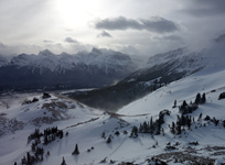
Above: A stunning view of Stelfox, Allstones, Abraham and Abraham Lake from near the basin.
August 31, 2015 / minute read( words)
Aside from the isolated Mt. Michener, no other peak in the “David Thompson Country” dominates the landscape over Abraham Lake more than Elliot Peak when coming from the east. I had wanted to climb Elliot Peak from the moment I learned from Eric Coulthard that it could be done as a scramble, but various circumstances had kept me away until a long awaited reprieve from poor forest fire conditions left me with a free Monday to tackle a day trip from Edmonton.
Starting from my car at around 6:00 am in the morning I set out for the large basin between Elliot Peak and Sentinel Mountain, enthused to finally be ascending the former and excited at the possibility of proving the viability of the high traverse over to the latter. Although many felt the traverse to Sentinel could be done by skylining the ridge above the cirque, it had yet to be confirmed formally online as various parties gave up on the idea due to fatigue, darkness or weather.
The scrambling traverse over to Sentinel is not only viable (moderate difficulty, whereas Elliot, is technically a difficult hike), but far more enjoyable than the ascent of Elliot was. However, a misguided decision to avoid some significant backtracking led me to traverse the knife edge ridge from Sentinel's main summit to its northern sub-peak, seeking a more direct descent, and that's where the day's real adventure began.
Routefinding
Finding the Trailhead
The trailhead for Elliot Peak is thankfully super easy to find as it's right next to a marked bridge over the Cline River on the David Thompson Highway (#11), not far from the David Thompson Resort and a helicopter tours centre. If you're coming from Rocky Mountain House you'll even have the bonus of a mileage countdown as “Cline River” is listed as one of the destinations on highway signs.
Sidenote: I strongly recommend leaving Rocky Mountain House with a full tank of gas. Your options in this region are either super expensive (Saskatchewan River Crossing), limited in octane choices, limited in business hours, or very sketchy; and usually a combination of all four.
A few hundred metres southwest of the bridge you'll find a dirt road heading into the trees (on the west side) that leads to a sheltered parking area. This would work as great spot to sleep overnight in a car or if you've got a tent with you, there's a camping area (no registration or fees required) at the top of the hill to the north that has a screened toilet. You'll find the trailhead for Elliot Peak (and a number of destinations on the south side of the Cline River) in the northwest corner of this open parking area.
Although the route was recorded with a GPS unit, this data should only be used as a SECONDARY navigation tool.
Ascending Elliot Peak
With multiple ascents taking place over the last 3-4 years the beta surrounding Elliot Peak has improved considerably, going from a lot of rough, exploratory bushwhacking to the relatively easy approach shared with me by my friend Geoff Hardy. His suggested route starts with an easy hike on a pleasant trail for 2km to what's referred to as the “second drainage”. The first drainage is a little braided and crosses the trail somewhat indistinctly, but the second is unmistakable as the trail dips into a wide, rocky drainage with a bridge. Roughly 30m before this drainage you should see a tree with orange flagging tape on the left next to a subtle animal trail; this is where you want to begin your ascent.
The forest next to the drainage is open and, even though the animal trail disappears from time to time, is incredibly easy to pass through. As long as you keep the drainage within sight, you can't really go wrong here. Once you've ascended for about 1.5km through the forest the ridge you're on will begin to trend upwards to the climber's left; it's around here that you'll want to start looking for an easy descent into the drainage (likely requiring some easy side-hilling) and continue directly up the creek, sticking to the climber's left when it forks. After a period of boulder hopping and a quick passage through a small section of forest you'll find yourself in the big, open basin between Elliot and Sentinel having already gained close to 800m of elevation.
Although the summit won't look far away, know that every view here is foreshortened and that you still have 729m to gain, and a long way to go!
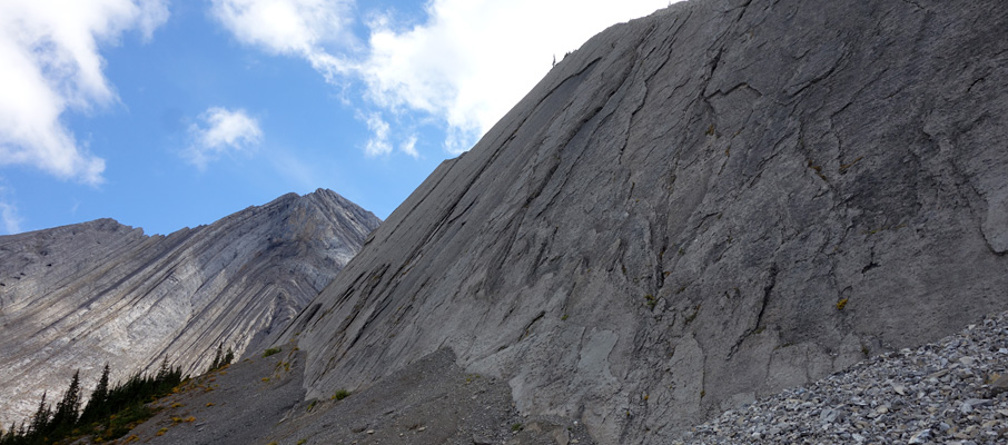
From the basin head upwards towards a visible weakness in the lower cliffs (centre right) of the giant cirque that links Elliot and Sentinel. A switchbacking slope here provides easy access to a huge, somewhat down-sloping, scree ramp that leads all the way to Elliot's summit ridge. Even Sentinel looks like it can be directly ascended from this point on easy screen slopes to the climber's right, but note that this line looked insanely steep from up high on both Elliot and Sentinel. You'll want to nix those thoughts.
I purposely took a high line along this ramp eliminating exposure as a concern and hoping for solid ground but found that there's no escape from how loose everything is here. Frankly, one of the worst slopes I've been on all summer.
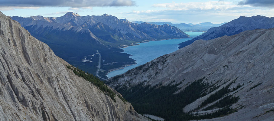
How bad is it? While doing some easy side-hilling within 50m of the summit shoulder all the scree released around me, sweeping me off my feet and forcing me to self-arrest using my palms (by using downward pressure and grabbing at anything I could). Thankfully my 30m slide put me at no risk of going over a cliff and, as with a similar incident on Roche-de-Smet, the Mechanix Wear gloves I normally wear saved my hands from injury. Understandably, this left me in a somewhat foul mood as I took in the great views of Abraham Lake, Mt. Ernest Ross, and the surrounding area from Elliot's lofty summit soon afterwards.
Sidenote: Rockfall's not a real concern on this ramp as you're almost always travelling perpendicular to the fall-line. While rain shouldn't cause any issues, the presence of significant snow or ice would make this ramp a dangerous place.
If you're only interested in bagging Elliot Peak, the descent simply retraces your steps back to the parking area.
The Traverse to Sentinel Mountain
Although it may look a bit rough from the summit of Elliot, the ridge above the cirque is broader than it appears and is reasonably easy to traverse. After dropping about 250m from the summit I headed for the ridge crest and began bypassing a large fin section on the climber's right. Although not particularly difficult, this was the crux for me as I didn't trust the ground beneath my feet following the earlier incident. Thankfully I was soon able to regain the crest where the rock was pretty solid.
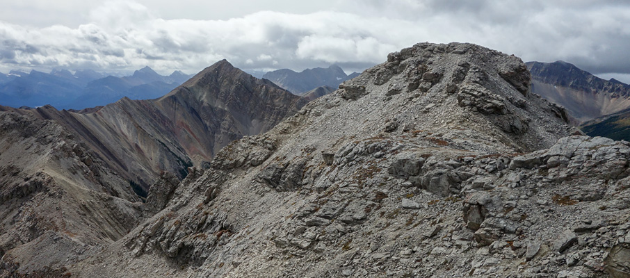
There's not much to be said about the rest of the traverse. A high point midway across was easily bypassed using ledges on the climber's left, Sentinel's western sub-peak is easily ascended on scree slopes to the left of a vertical rib (where from the top, you can contour around the climber's right to avoid needlessly topping it), and the final section between this sub-peak and main peak requires a few short downclimbs (2m-ish) that weren't a big deal. The exposure along the route was pretty mild, and certainly far less than I expected. It took me 1:20 to cross over to the summit. Expect at least the same amount of time to return.
The summit cairn on Sentinel has no register, which is unfortunate as I would guess it receives few visitors.
The views aren't significantly different than Elliot's, although it will give you a better appreciation of how steep the cirque is linking the two mountains. This perspective is particularly useful as it will discourage you from shortcutting the tragic backtrack to almost the summit shoulder of Elliot, which is where you can finally perform a safe turn around a dividing cliff band and then make your way down the ramp towards home and, if you're wise, ice cream.
Pioneering the Wrong Route Down
While avoiding some heavy self-psychoanalysis here, I will admit that I departed Sentinel's main summit for its northern sub-peak knowing that on one level, if not several, that I was being irrational and that it was probably a bad idea. I think at its core, scrambling as a pastime depends largely upon this capability. I even posted a message using my satellite device indicating I was headed for a northern descent, just in case it went sideways because, obviously, I suspected it would.
I was hopeful that I would find a moderate descent leading towards the Cline River on the other side, and stubbornness kept me going even when I didn't. The thought of backtracking all the way back to (almost) Elliot's summit, and then descending that loose ramp would have to be the worst option? Right? Well, let me tell you...
After crossing to the north summit on the knife-like ridgeline (which required a brief backtrack to find a bypass on the climber's left) I didn't find any moderate descent slopes; just two narrow ridges: one heading to the northwest which didn't look great, and one to the northeast which looked even worse. With those options dashed, I contemplated the two bowls which descend from between the two summits.
The west bowl looked promising all the way across; no signs of difficult cliff bands from any vantage point, and it looked like it exited to a bit of an open gorge with accessible forest areas leading towards a broad tributary of the Cline. If it worked it would add several kilometres to the hike out. Meanwhile, this was the first place I had seen where I could safely access the east bowl, but it looked like it would be easy sailing after a cliff band or two, and that those cliff bands would offer numerous spots where they could be bypassed or easily descended. The best part was that it was a direct route back to the ascent drainage. “Since I'm here”, I thought, “it's worth a look”, and began my descent.
The pictures (below) largely tell the story. Suffice to say that the east bowl route is a relentless, difficult scramble, bordering on a climber's scramble, with complex routefinding. I had a large boulder roll out from under my feet midway down, which led me to fall so hard on my elbow that it split open and rendered my left arm useless for about 10 minutes. I was very lucky not to break anything.
I recall four major cliff bands and hundreds of small ones. The first major cliff band required a short, exposed friction traverse on slab into a front-pointing downclimb towards the skier's left of the bowl, the third required an epic traverse to the far right below a cave feature, and the second and fourth cliffs were only passed thanks to what I've dubbed “hero gullies”. These were gullies that I found in the adjacent northeastern bowl (somehow an even bigger gong show than the east bowl) when I was absolutely out of descent options that weren't “let's spin the wheel” dangerous.
Coming across the exact terrain I needed (an easy descent gully through the cliff band, followed by an easy ledge back to the east bowl), twice, around a corner that looked like it might only offer open air, in a steeper, more treacherous bowl, is almost enough to make one go to church... almost.
I'll never forget the fourth major cliff band at the bottom. It looked like it was going to be steep and when I poked my nose over the horizon I was dismayed to see that it was roughly 100m of unbroken slab, with a pitch averaging about 60°, that is essentially continuous around the whole eastern half of Sentinel Mountain for about 2-3 kilometres. I just stared in stupefied awe for a while before deciding that this development was downright unsporting. Shame on you Mr. Mountain!
I was faced with the real possibility of an epic retreat that would see me reach Elliot in darkness, several hours later, while standing no further than 100m away from sweet, sweet freedom. The only weakness I could find seemed unreachable, far to the skier's left, and I edged towards it like a madman on exposed slopes before lucking upon my hero gully. Even then the feature turned out to be akin to a really steep, dry water slide between two slab-like strata which I have forever dubbed “The Long Scouch Goodbye”.
It suffices to say that I kissed the ground after I got off the mountain. It was the worst downclimb I've done with the exception of Mt. Rundle, where Steven and I had to butt-scouch on scree slopes due to the steepness and downclimbed past rap stations... twice. With all that stress released, walking back through the forests of the Cline valley, with the afternoon sun filtering through the canopy so beautifully, felt absolutely wondrous! I then proceeded on to Rocky Mountain House where luscious ice cream awaited my return.
As this is the Internet, I will credit myself for having made the first ever west-east traversal of Sentinel Mountain, and there's not a whole lot you can do about it. I will also credit myself for being a dumbass for having done it. So when you do Sentinel Mountain remember to suck it up and backtrack... or try that west bowl, it looked good to me and I'm clearly a reliable expert on such things.
2017 Update: When viewed later from nearby ‘Bridge Peak’, that west bowl is great until you run into the same kind of giant slabs I encountered on the east side.

 from the drainage")


 from the summit")