
Mount Hardisty
“They hunted us relentlessly, all the way up the mountain.”
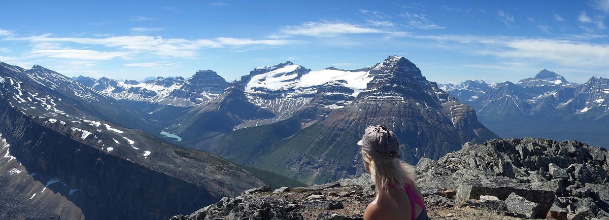
Above: Taking in the beautiful vista surround Mt. Kerkeslin from the first of three highpoints on Mt. Hardisty.
June 27, 2015 / minute read( words)
While I love Jasper National Park and consider it my home away from home in Alberta, I must admit that there are times when you really don't want to be there. Specifically, times when weather conditions and an incredible congregation of small lakes within a fortified valley produce a spectacular explosion in the local mosquito population. In the past such blooms have led to tales of weary scramblers being swarmed on 2,700m summits, or forced to flee their campsites in speeding vehicles, and while we'd all like to attribute such tales to myth and exaggeration, they may be all too true... as Vicki and I would learn on this day in late June.
Upon stepping out from the safety of our vehicle at the trailhead, equipped only with the vague concept of Ben's winter ascent and hopeful enthusiasm, they were waiting for us. In the millions. Hungry, and ready for the cattle drive to come.
This would not be a tale of an enjoyable scramble with surprisingly little bushwhacking (once you know the route), or of one with lovely views including the five tallest mountains in the Rockies (Columbia, The Twins, Mt. Alberta, Mt. Clemenceau and Mt. Robson). No this would be a saga of humans vs. mosquitos; of two adventurers braving their own mortality, ascending to a distant point in the sky, and casting hundreds of their squished dead to the everlasting winds of the Maligne. And then going for beers afterwards, as one does in Jasper.
Routefinding
The Approach
An ascent of Mt. Hardisty begins from a small parking area on the east side of the Icefields Parkway (Highway 93) that you'll find roughly 1.6km northeast of the turn-off to Athabasca Falls or 30km south of the town. Walking south from the parking lot on a worn trail will quickly lead to branch and a choice between two options: heading left on a trail that vanishes after 50m of travel, or head right and follow the nice Evelyn Creek trail to the base of the ascent ridge. Naturally, we headed left... since the other branch appeared to be headed in the wrong direction, away from Mt. Hardisty.
Although the route was recorded with a GPS unit, this data should only be used as a SECONDARY navigation tool.
Once the left trail faded out of existence we were faced with 2km of tedious, but not particularly difficult bushwhacking. We headed east along a small creek and periodically consulted my GPS unit to ensure that we were still on course for the base of Hardisty's mellow southern ridge. Every time we slowed to correct our heading or determine a route around the next section of vegetation, we'd be set upon by dozens of mosquitos. It was a miserable approach, but soon enough we reached the base of the ridge and began our ascent.
What we should have done, obviously, was follow the unsigned (but regularly blazed, and occasionally flagged) Evelyn Creek Trail as we discovered on our descent. Following this pleasant trail for 2km will bring you to near the base of Hardisty's ascent ridge. Note that if you slavishly follow our GPS track there you'll find yourself ascending very loose soil on a steep embankment to escape the creek; a slope which we side-slid down while holding on (for dear life) on to various tree branches. Instead, as you near that 2km mark watch for the creek's embankment to begin rising above the trail to your left as the trail drifts closer to the creek on your right. When you notice this happening, leave the trail and follow along the top of the bank and deal with the mild bushwhacking until you reach the base of the ridge within a few hundred metres.

The Ascent
Aside from the occasional downed tree or dense cluster of bushes, the forested southern ridge of Hardisty is pretty open and the routefinding is easy: head upwards. We had hoped that climbing out of the densest forest and getting away from all those ponds, creeks and other bodies of stagnant water would improve the mosquito situation, but alas, no. The harassment was constant, we could never afford to stop, and the mercury was rising quickly (and would peak at 33.5ºC later that day). I kept thinking to myself that a strong wind would resolve all of my problems, but there was nary a breeze within the forest. I had to satisfy myself by fanning my overheating body by violently swinging my arms around to squish any who dared to land on my forearms or neck. There was no shortage of volunteers.
I imagine that I'm not the only one puzzled as to how a smorgasbord of evidence of mosquito death around an individual wouldn't act as its own natural repellent. If I came across a giant ice cream sundae surrounded by rotting human corpses, I wouldn't casually stroll up to it, spoon in hand. Perhaps this fact alone explains why humanity is on its way to Mars, while mosquito kind has failed to push their life expectancy beyond a handful of days?
Anyway, I was plagued by many a deep thought as we neared the treeline and were treated to our first views of Kerkeslin on a steep rocky slope. The slope relaxed considerably at its top, and from there it's easy hiking with open views to the base of the first of three ‘humps’ that form the summit ridge of Mt. Hardisty. Best of all there was a slight wind... a sweet, sweet marginal wind.

Like many mountains in this area of the Rockies, the summit humps of Hardisty are comprised mostly of piled quartz boulders. We did our best to pick an easier line up the bouldery slopes of the first hump, and from there the best route is right along the crest, over the second hump, and then on to the summit. Both the first and second humps are followed by short downclimbs. In dry conditions, both of these downclimbs require easy to lower moderate scrambling, with the second one being slightly more challenging thanks to an awkwardly slanted ramp. Exposure isn't an issue along the summit ridge, but you do need to be careful of moving boulders and the frequent slots that form between them.

As evidenced by my many photos from this trip, the views from the summit ridge of Mt. Hardisty are excellent. You can really see a significant amount of Jasper National Park from this mountain, and the summit aligns quite neatly with the southeast summit of Mt. Kerkeslin so that it's bookended by Mt. Alberta and the Twins on one side, and Mt. Columbia on the one side. Speaking of Columbia, this might be the best sight line for it on a scramble north of Sunwapta. Mt. Robson was also clearly visible, but hot bluebird days in Jasper always seem to produce heavy amounts of haze between Jasper and the Canadian Rockies' tallest mountain.
The summit has a register, and it shows that at least half a dozen parties a year make their way to the top. That there's virtually nothing written about this mountain is therefore puzzling... it's as though all of these individuals were devoured alive by mosquitos on the descent. A plausible scenario. Thankfully for us, the mosquitos had lost our trail during our extended time on the summit ridge and we managed to escape, un-devoured.
The Descent
Share this report on:
Descending Mt. Hardisty is simply a matter of retracing your steps down the southern ridge. However, one thing to take careful note of is that southern ridge is quite broad and, once you're in the forest, you can easily drift away from your ascent route if you simply follow the fall-line. I was likely “zoning-out” to thoughts of our après-scramble meal and beverages when Vicki raised concerns that we were headed way off route, and she was right. Halfway down the mountain, we were already a good 200m further east than our ascent route*. Consulting the GPS unit every now and then and correcting kept us right on course for the rest of the descent, where my unimpressed companion and I discovered the Evelyn Creek Trail, and that we had been bushwhacking almost next to it for our entire approach that morning.
* Depending on how the southern ridge meets Evelyn Creek, and how the Evelyn Creek Trail continues along that stretch, getting off route on the descent may not be a big issue. That said, correcting your trajectory in the manner we did is the likeliest way to stay out of trouble.


")


 across the valley.")


 in the far distance. This can be scrambled from Evelyn Lake.")
 and Columbia flank the southeast summit of Kerkeslin.")


")


