Mount Hood
A beautiful volcano with many concealed dangers.
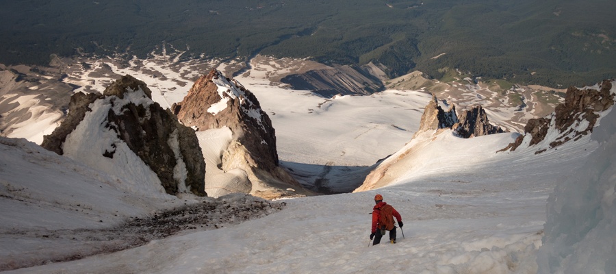
Above: A look back at Crater Rock and the summit rim while descending from the volcano
July 05, 2017 / minute read( words)
After completing Mt. Rainier perfectly on schedule, Jason, Raf, Dalia and I found ourselves with plenty of time and good weather to tackle another objective in the Pacific Northwest. Our first thoughts were of nearby Mt. Adams or Mt. Saint Helens, but getting permits for the former was going to be difficult to time correctly while crossing the state (you need to pick them up in person during business hours) and the latter seemed to have some ridiculous hoops to jump through in order to get a permit (no same day availability, everything needs to be printed, additional passes just for the area, etc...). So what to do?
While weighing our options over plates of poorly syrupped pancakes at an IHOP, it occurred to me to check to see how far we were from Portland and the answer (around 2 hours from our sketchy motel in Puyallup) was much shorter than expected. A few quick Google queries later we had discovered that Mt. Hood functions on a self-registration process, that's available 24-hours a day, costs nothing and is found right at the trailhead. We were immediately sold. So long Washington!
It was the Fourth of July when we rolled into the Gresham, a suburb of Portland, and, like any red-blooded American would, we celebrated the day by downing some cheap pan pizzas and going to bed at 7 pm in anticipation of an early ascent of the state's highest point. This turned out to not be the greatest plan as the neighbourhood soon thundered continuously as fireworks raked the sky like a carpet bombing. Refreshed, but not quite rested, we left the hotel with our gear just in time to disturb a classy gentleman celebrating his country's independence with his favourite prostitute
Routefinding
Registration and Escaping the Ski Resort
Planning to keep our trip as quick and easy as possible, we chose to tackle the standard South Side/Hogsback route on Mt. Hood. To get to its trailhead, we took Highway 26 east from Gresham to Mt. Hood National Forest where we eventually turned north onto the Timberline Highway. After a short drive, we reached a collection of parking lots (the first on the right is the climber's lot) and the day lodge (first large building on your left) which contains the self-registration centre just inside its unlocked entrance. We took care of the registration (two quick forms, one of which you collect afterwards to ‘check-out’), parked at the climber's lot, geared-up, and walked into the night.
Although the route was recorded with a GPS unit, this data should only be used as a SECONDARY navigation tool.
The normal climber's route on Mt. Hood follows the right (eastern) flank of the ski resort from the parking area, and we followed this line for a period of time on a well-packed dry trail until we encountered the first of the snowfields. At this juncture, we could see an easy/dry trail to our left, and in the absence of any real signage or sunlight, headed in its direction. We continued up the mountain in this fashion, simply picking the easiest lines we could see by headlamp until we were past the resort and making our way up the snowy slopes to Crater Rock.
It wouldn't be until our descent several hours later until we got a true sense of just how far we had strayed into the ski area during our ascent. However, considering the number of surprise hazards (crevasses, large holes, and stretches of exposure) we discovered near the bottom of the “official route”, we were certainly happy that we hadn't come that way in darkness. It wasn't clear whether the climbing route includes glacier travel at that point, or whether the snowfield built by the resort was simply falling apart at the edges (more likely), but you definitely want to stay on your toes as the dangers are considerable and very unexpected based on what we had researched.

Upwards and Umbras
Dawn began to break as we continued up the snow slopes above the ski resort, now travelling with our crampons on and ice axes in hand. Soon thereafter I became really stoked when I noticed faint, but perfectly angular lines forming on the clouds to the west. I had seen this phenomenon most recently on Elbrus in Russia, where if you're high on a prominent mountain at dawn the conditions can sometimes conspire to generate a perfectly triangular shadow on the opposite horizon (a result of the perspective effect). My climbing partners didn't really get my excitement at first, but as the lines became more pronounced, and the shadow darkened, the significance of what was happening became obvious and our progress slowed as the burden of activity transferred from our legs to our cameras. This may be a common occurrence on Mt. Hood, but it's something I witness maybe once out of every 60 ascents I do. And it's pretty awesome, every time it happens.
In clear conditions, the routefinding between the ski resort and Crater Rock is fairly mindless: aim for the right side of that distinctive landmark and head up. While we transitioned here and there between the steady snow slopes and the occasional rocky ridgeline, neither presented any difficulties, and we soon found ourselves following a well-travelled trail around the Crater Rock's eastern side towards the Hogsback (a spine-like snowy highpoint within the crater that connects directly to the “Pearly Gates” summit route), and a group of hikers who had made that point their destination for the day.

Old Chute and the Summit
Our philosophy for this trip was to go light and fast and, upon seeing the massive gaping chasm of the bergschrund (that could easily devour a bus), we knew that the Pearly Gates was out the window. The Gates is a steep, narrow chute that ascends directly to the summit above where the bergschrund typically forms, and without our ropes, ice screws, or crevasse rescue gear, it was too risky to attempt on this day. So we traversed over a seemingly innocuous snowfield to the base of the Old Chute route, which offers a more moderate snow slope to the summit. Don't be lulled into a false sense of safety on this traverse due to the heavily plodded trail; steam venting from fumaroles at the far end eat away at the snowfield from below, and likely cause portions to collapse at random times throughout the summer.
Having read of rockfall being an issue on Mt. Hood and being reminded of that reading by a large rock bounding down the mountainside during my traverse, I had my helmet on and was eyeing the cliffs above with suspicion as Raf, Jason and Dalia joined up. With no recent snow, the mountainside had been shaped into a continuous staircase by a parade of climbers and we found the going steep, but not challenging. By mid-slope, a gap had opened between Raf and me, and our companions, and that's when the wind picked up and sent a slew of debris down the mountainside.
You know when, in an animated cartoon, a kitchen chase scene eventually launches an entire drawer of knives at a participant? A very similar scenario played out as the cliffs above us suddenly released not one, or two, but nine chunks of ice and rock at once. Raf and I were already past the debris' fall line, but Jason wasn't, and thankfully my warning yells caught his attention in time for him to realize that he was in deep shit. With falling, bouncing debris being so unpredictable in trajectory, he did the only thing he could... he stood his ground and waited until the last moment to choose his dodging direction as the rocks and ice chunks whizzed past at high speed. Thankfully he dodged well, and I wasn't surprised to see both him and Dalia retreating to safer terrain soon thereafter. High on the slope, and not entirely out of danger ourselves, we hastened our ascent and soon lost sight of them as we rounded a corner towards a series of chutes to our left that lead to the summit.
Share this report on:
The chute we chose was steep and icy but in a really inconsistent manner. Some steps were solid ice, some seemed ‘hollow’ in a manner that wasn't reassuring, and then the rest were snowy and allowed us to self-belay with our ice axes. Thankfully the chute was short, and after a series of careful steps, we found ourselves on the broad summit ridge, minutes away from the summit proper.
Unfortunately, the time it had taken us to ascend from the Hogsback to the summit (roughly 45 minutes) had seen the beautiful blue skies of the morning give way to gloomy clouds and a black layer of fire smoke, which we could only guess was blowing in from Northern California. Our views were limited, but we had done so well on that front to this point that it was hard to complain. After spending some time exploring the summit ridge, we returned to the top of the chute and were surprised to see Jason climbing up it. I was happy to see him get the summit after the earlier close call, and the three of us made our way down together without incident to rejoin Dalia in the parking area.
Although my energy levels had felt good throughout the climb, fatigue hit me like a wave at the bottom. We checked out at the registration centre, and after a mere 15 minutes of driving, I had to pull over and hand-off the driving duties to another team member. Thankfully at this point, our trip to the Pacific Northwest had been a total success, and there was no pressure to keep pushing hard as we returned to the Portland area for a much deserved celebratory lunch.


")


")
")


")