

Mount Mary Vaux
“...amazes from the halfway point and then only improves.”
Above: Charlton, Unwin and the rest of the magnificent Maligne Lake region from the summit.
August 8-10, 2014 / minute read( words)
If it weren’t for the glacier travel required to ascend the last 100m to its lofty 3,208m summit Mary Vaux would arguably be one of the best scrambles in Jasper National Park. Not because the climb itself is anything remarkable, an easy slog with the occasional short cliff band which dips wildly into lower moderate territory, but rather due to its revelation as a spectacular vantage point.
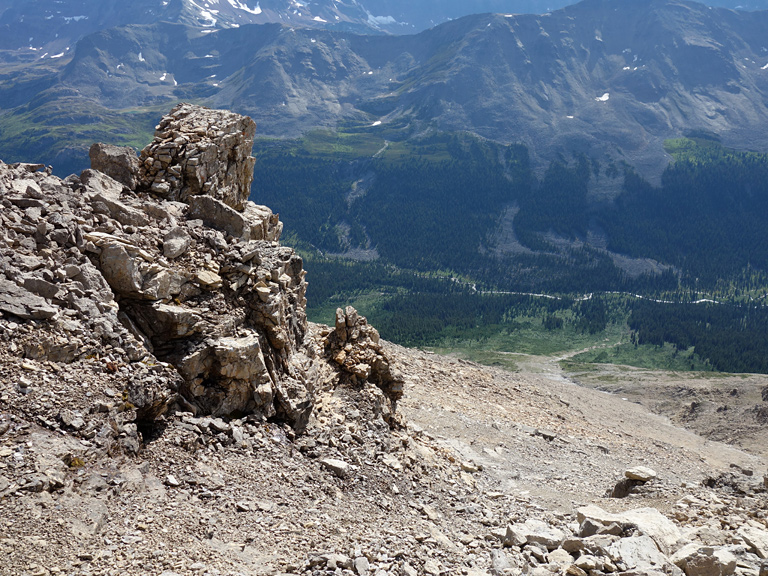
Nestled far from the Icefields Parkway between Maligne Pass and Maligne Lake, Mt. Mary Vaux’s central location and prominence affords sweeping views of Jasper National Park, including the entire western half of the park*, almost every landmark mountain and 11,000er**, and a wonderful aerial view of the aquamarine waters of Maligne Lake. The best view though emerges from the perfect alignment of Maligne Pass, its several brightly coloured lakes and tarns, and the distant Columbia Icefields; which amazes from the halfway point of the climb and only improves as you gain more altitude.
* And actually beyond, as everything from Mt. Forbes in Banff, to Mt. Robson in B.C., is easily identifiable to form a stunningly continuous 205km skyline! ** Exceptions being Roche Miette which is way too small to be seen much beyond the Jasper Lake area, and Mt. Columbia which was hidden from view behind the giants North Twin and South Twin.
Mary Vaux, due to its isolation, requires a multi-day expedition to summit but is well worth the effort. Thanks to quality trail access from either Maligne Lake or Pobotkan Creek, and a decent campground at its very base, it can easily and comfortably be done over a weekend.
Routefinding
The Approach
Vicki and I began our trip began from the Pobotkan Creek parking area which can be found off the Icefields Parkway roughly 70km south of the Town of Jasper. You’ll find the parking area on the south side of the creek and, and from there you’ll walk across the bridge and find the Pobotkan Creek trailhead just behind the Warden’s residence next to the creek. 6km of walking along this well-maintained, but rather viewless, trail will bring you to the “Pobotkan Junction” where you’ll find the Maligne Pass Trail.
Although the route was recorded with a GPS unit, this data should only be used as a SECONDARY navigation tool.
Despite being “decommissioned” by Parks Canada, the Maligne Pass Trail and its campgrounds (Avalanche and Mary Vaux) are still fully equipped (fire pits, bear poles, and toilets) and in very good condition. Heading both north and upwards the trail to the pass (roughly 9km) would see us cross Poligne Creek several times (always bridged) before arriving at the Avalanche Campground for our first real break of the day.
From there we noticed some weather chasing us from the valley below and were soon engulfed in a thunderstorm as we neared the pass. Forced to take cover amongst the trees, we were treated to a lengthy sonic assault as thunder boomed over Replica Peak and then roared continuously for a dozen or more seconds as it reverberated off the amphitheatre-like cirque of the aptly named Endless Chain.
Denied the opportunity to climb Replica Peak or explore the tarns on the western side of the pass by the weather, we made the best of a break in the storm, rushed the rest of the distance to our campsite (a total of 20km for the day) and retreated to the tent for the night at a ridiculous 5pm due to repeated downpours. Low hanging clouds had completely prevented us from scouting potential routes up Mary Vaux.

The Ascent
The weather cleared and then cooled considerably overnight and we awoke the next morning to a thick layer of frost. Hoping to make our way past the heavily forested slopes below Mary Vaux before they could defrost and soak us would prove an abject failure as what appeared to be a grassy slope to the immediate east of camp turned out to be nearly impenetrable, chest-height shrubbery. Soaked and numbed we soon made a hasty retreat back to camp.
After a change of clothing, I began to scout both north and south of the campground along the main trail to find an easier route. I would find a better spot to the north of camp, and would then improve upon it during my descent.
Where you want to begin your ascent of Mary Vaux is from near a dry creek bed 0.5km north of the campground. As shown in image #13, this creek bed is right next to old growth forest, is a bit overgrown, and can be seen to link up with a drainage further up the mountain. Due to the creek being overgrown and having a good amount of deadfall further up, your best bet is to bushwhack through the old growth forest to the immediate left of the creek and then rejoin the creek further up the mountain near the end of the treeline (see image #15). There were plenty of open spaces amongst these trees and the going was pretty easy.
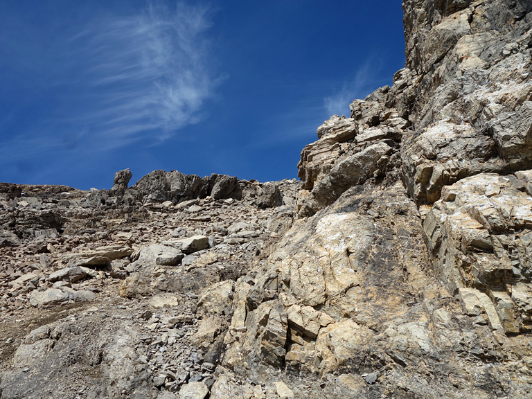
Once you’re in the drainage above the treeline (still more than 1,000m below the summit!) the next section of the ascent becomes very clear. Referring to image #16 you want to follow the trajectory of the drainage in the photo on a right-trending diagonal to a distinctive rock outcrop on the skyline. There’s no difficulty in reaching this point on the ridge, only physical effort. However, at 2,500m you’ll already be getting great views of Maligne Pass and the surrounding area.
Ascending from the rock outcrop on this ridge to the summit area of the mountain is where you’ll encounter some hands-on scrambling, most of which can be bypassed to either the climber’s left or right. I headed straight up along the crest for the first few small cliff bands before I came upon a 6m cliff with downsloping, and slightly overhanging steps. Before that could potentially spice up the difficulty of the climb, I scouted to the climber’s left and found a broad gully that would allow me to completely bypass the challenge.

This should be pretty easy to figure out on site, but the illustration in image #21 and the cairns I built through this area should hopefully make the way obvious. Beyond this bypass the rest of the ascent is pretty much a hike until you reach the glacier.
The Glaciated Summit
I had always suspected that Mary Vaux’s summit would be snow covered, if not glaciated, and had debated back-and-forth about bringing crampons before deciding the extra weight over 50km would hurt less than not having them at a crucial moment. Just as well, as it’s not possible to summit the mountain without travelling on the glacier (you also can’t see Maligne Lake without ascending the glacier).
Don’t be fooled by the scale in image #30; the glacier is contouring around the precipitous south face and you need to follow the glacier’s crest for a while to avoid a substantial cornice on the climber’s right before you can retreat to the scree on the distant right just below the horizon.
Now I should preface the following part by pointing out that solo travel on any glacier is a dangerous and stupid idea. I gave the glacier a really good look; no visible crevasses, no sagging, the bergschrund was far down the north side on the climber’s left, the cornice over the south face was easy to see and avoid, the slope of the glacier was really mellow, and I could see a line of bare ice almost the entire distance; that said, I was also aware that I could easily be wrong. Treading carefully with my crampons and ice axe I made my way up the icy crest of the mountain and soon found myself at a large rock cairn at the summit.

Share this report on:
It wasn’t until I was a bit past the summit to where I found a break in a large cornice overhanging the eastern face of Mary Vaux until I was finally afforded an unobstructed view of the Maligne Lake area and an eastern panorama of mostly unnamed peaks. While I could have travelled further along the summit ridge to a southern point that may afford great views of Maligne Lake and the Coronet Creek valley, I wasn’t willing to tempt fate further by traversing a sketchy ice slope best seen in image #38. Self-arrest seemed doubtful on that downsloping ice rink and could produce an exhilarating high-speed luge run off of the south face of the mountain.
The views from the summit were simply stunning and helped produce some poor editorial control in this trip’s photo gallery. After devouring a delicious peanut butter, chocolate and pretzel Cadbury concoction that tasted like victory, I carefully made my descent of the glacier, before enjoying the beautiful views all the way down the western face of the mountain to the campground.


")


 and Maligne Pass")


 and Kerkeslin (centre) in the Distance")


")


, South Twin and Twin's Tower dominate the skyline on the right, while Mt. Bryce peeks over the icefield to the left.")


 and Catacombs Mountain (right)")


")
 and Mt. Charlton")
")


")
 and an unnamed outlier")


