Mount Willingdon
“Spite is one of the most reliable forces in the universe.”
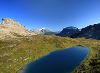
Above: Devon Lakes, Devon Mountain and the Clearwater River Valley from the ascent route on Crown Peak.
September 7-9, 2013 / minute read( words)
I began to grit my teeth as I looked at the weather forecasts. Willingdon is (as of this writing) by far the most distant and isolated peak I've ever attempted, and things were looking grim. A heavy storm system would be rolling through the area over the planned three days; an area whose wide open valleys are known for leaving its visitors exposed to the elements. It also wasn’t of any comfort to know that a friend’s group had completely fallen apart before reaching Quartzite Col the previous weekend under similar conditions. I began to assume that I was committing to some quality suffering. It turned out that I wasn’t the only person eyeing the forecasts with concern.
When I gathered with Wayne, Estelle and Bruce on a Saturday morning for this ACC-Jasper club trip I was informed that two members had bailed at the last moment due to the weather, one being an individual who had made three failed attempts on Willingdon. While I’ll never claim to have all the answers, I have observed that spite is one of the most reliable forces in the universe. Upon hearing that this cursed individual wouldn’t be accompanying us my disposition improved because I knew that we were destined to successfully summit this 11,000er, if for no other reason than to pile more suffering upon that unfortunate soul.
It would turn out that I was right; our entire group successfully summited Mt. Willingdon under reasonable conditions; and I, clearly a glutton for physical punishment, also fought my way back up the mountain to summit nearby Crown Peak and South Tower.
Routefinding
The Approach
Most attempts at Mt. Willingdon begin from a roadside parking area adjacent to the Mosquito Creek Hostel on the Icefields Parkway (Hwy 93), roughly 26km northwest of Lake Louise. From this parking area, cross the road and then traverse the bridge to a signed trailhead which follows the creek on a northeast heading between Dolomite and Noseeum Peaks.
You’ll be following this trial for roughly 4km along the creek before leaving it right at the beginning of a fourth bridge (which spans a much larger body of water than the ones before it). You should see a cairn and a small trail heading to the left as shown in image #2. For the next 3.5km, you’ll be following a series of minor trails, and likely switching from one side of the creek to the other as trails vanish.
Your goal in this area is to reach a valley between Ramp Peak and Quartzite Peak which leads to the infamous Quartzite Col. Unfortunately you can’t see this from the valley and that, combined with plenty of rain and low cloud, resulted in us traveling much further towards Watermelon Peak than necessary (as you can see from the GPS track). I suggest referring to images #3 and #4 for this area; #3 shows the gully you’ll want to ascend on the right(east) side of the creek, and #4 shows the opposite view with some distinctive cliffs on the west side that can be used as a landmark.
Although the route was recorded with a GPS unit, this data should only be used as a SECONDARY navigation tool.
Quartzite Col
I had read a lot about Quartzite Col before leaving for this trip, and mostly from very experienced climbers and scramblers who found the experience traversing this significant shortcut to be rather scary. It’s a natural inclination for people to head towards the lowest point of the saddle here but this leads to a chute on the other side; one that approaches a 40° slope and is usually covered in snow and ice (see images #11 and #12). There have been some nasty falls here in the past, thankfully none fatal.
The key to Quartzite Col (which was thankfully taught to me by fellow scrambler Taras) is to head higher on the right side of the saddle to a spot that can be identified easily by two different features. If you look at image #7 you can see both of these features: the first is a square looking rock tower with what appears to be (but isn’t) a cairn on top, and the second is a highly visible “seam” of different coloured/textured rock which leads directly to it. A descent from here (shown in images #8 and #9) is of moderate difficulty at worst. The first few metres look quite steep, but from there we swung out to the skier's left (north) a bit and contoured around the snow and ice visible in the photos to a small basin below. The third option that's shown in image #7, higher to the climber’s right, requires a bit more elevation gain but leads to a nice long scree run into the same small basin discussed above.
From that basin, you’ll be faced with a tedious descent on loose rock and boulders before reaching the welcome relief of the grassy plains in the awesome Siffleur River Valley. A very pleasant hike across this valley will see you cross a pair of small headwater streams and pass by a few tarns before reaching a trail on the northeastern side which eventually branches towards Clearwater Pass and the Devon Lakes.

Devon Lakes
The Devon Lakes area has a reputation for being one of Banff’s best camping areas and it certainly lived up to everything that I’d heard. The morning’s gloom of steady rain and low cloud had begun to give way to increasingly better weather as we crossed the Siffleur Valley and we were treated to a beautiful sunset later in the afternoon.
We setup camp near a stream, and not far from the foot of Willingdon’s west ridge (at an altitude of roughly 2,300m). The skies were completely clear the first night and I repeatedly poked my head out of the tent to take in the incredible view, witnessing several shooting stars and the complete absence of artificial light. It’s simply an amazing location and we had the entire area to ourselves! I will definitely need to return here for more exploring and scrambling.
Sidenote: I've been asked how we stored our food while camping in this open area. As there are no trees over a few feet in height, we placed our food under an overhang on a large boulder and then sealed it in by leaning rocks against them. Although there were signs of bear activity in the area, we never saw any and experienced no nibblage.

Mt. Willingdon
Sidenote: From our base camp at Devon Lakes the stats for my ascent day were 9.5 hours, 13.2km, and 1,851m of accumulated gain. Being able to complete the direct traverse between Willingdon and Crown would considerably reduce all three numbers.
The photos really tell the tale of an ascent of the west ridge of Mt. Willingdon. The first third is a fairly easy hike; the second third traverses a much rougher area that requires a consistent amount of easy to moderate difficulty scrambling, and then the third part is a long slog combined with a crux cliff band.
When ascending the hiking section of the climb take careful notice of how precipitous the cliff bands are along the interior of the west ridge’s curve. Once you’re into the scrambling section or beyond, there’s simply nowhere to bail from that ridge aside from turning back, although it can look like there is from above along the ridge.
The scrambling section offers a variety of routes in most places, so you can exercise a fair amount of personal control over the difficulty and potential exposure. We stuck near the centre of the ridge for the most part until some larger cliff areas near the feature we named ‘BART’, or the big-ass rock thing, sent us to a worn trail on the climber’s right of the ridge. It’s also around this section where you’ll begin to encounter the appearance of sulphurous rock and its lovely, aromatic scent.
The only real obstacle on the mountain is a cliff band protecting the summit (see image #38) which, to complicate things, appears to be permanently drenched, despite the rest of the mountain being completely dry. Depending on the time of year, there’s a real possibility that these cliffs could be covered in ice.
The first few steps of this cliff can be tackled right from the centre of the ridge and will lead you to a shelf that can be followed far to the climber’s left (north) to the lowest section of the remaining cliff and the crux of the climb. The 2-3m climb here isn’t technically difficult; all the risk here comes from the combination of wet rock and a narrow, 1m-wide shelf lying between you and a 40m+ fall. A slip here could be very costly.
It should also be noted that there’s a lot of loose material directly above the crux. When attempting this section in a group, be sure to space people out accordingly.
A previous group had left us a solidly fixed rope to use for this section, which we did for some added insurance. We quickly reached Willingdon’s summit once we were past the crux, but unfortunately, it had clouded-in during our ascent and we could see very little. We spent a while at the top with no improvement and, abandoning any notion of traversing towards Crown Peak, we began the descent by retracing our ascent route.

Crown Peak & South Tower
I highly recommend making an attempt on Crown Peak and South Tower if the opportunity presents itself. While it’s possible to traverse to Crown Peak directly from Willingdon’s summit, the heavy clouds made evaluating the difficulty of that route impossible, so I parted with Wayne, Bruce, and Estelle, and rushed down to make a solo attempt via Willingdon’s south ridge.
The south ridge can be accessed from the head of the small valley between the hiking section of Willingdon’s west ridge and the main mass of the mountain. As seen in images #67 and #45 you need to detour around a large cliff band and then trend back to the climber’s right to eventually reach the Willingdon/Crown Col; home to a surprisingly large high altitude tarn.
Crown Peak’s status as an 11,000er is a matter of debate, but it’s clear that the GPS network feels it belongs (not only my device but those of several others who have made the effort). Reaching this lofty summit from the col is a fairly straight forward affair. I followed the corner of this pyramid-shaped peak for the first half and then slowly drifted to the climber’s right across its west face. The only challenge encountered while reaching the summit was a number of downsloping steps that need to be negotiated in the last stages.
Note that you will require at least two people to be able to open the copper register at Crown’s summit: the first to fail miserably, and the second to make fun of that first person while opening it on their first try (remember the universe operates on spite!). I had to settle for taking a picture of me holding the register.
With close to 2,000m of vertical gain already under my belt this day, I wasn’t sure that I really wanted to put in the effort to reach the summit of South Tower (which despite its semi-official naming is really a sub-peak of Crown). It looked far away and that it would require an equal effort to that of summiting Crown.
Share this report on:
Thankfully I was wrong on both counts as South Tower proved to be deceptively close. After making my way down to the Crown/South Tower col, I surprised myself by reaching its summit cairn within 8 minutes! Just as well, as I could see ominous clouds forming to the west and felt it best to begin the rather quick descent (thanks to a lot of soft scree) from the Willingdon/Crown Col to the safety of the valley below.
Those clouds drifted far south of us and I got to enjoy a great sunset dinner with Bruce, Wayne and Estelle as we reflected on the day. The next morning we would pack up and make the long return trip to the Icefields Parkway under sunny skies to complete a great weekend in the Rockies.
 and Mosquito Mountain (right)")

 after travelling roughly 2.5 kilometres along the creek")


")


 and South Tower (far right)")


")
")


")

")

")


")


")

")

")


")

")


 and Quartzite Col (centre right)")


")