

 September-24-2011
 The Columbia Icefields is a spectacular area bordering Banff, Jasper and the province of British Columbia; featuring dozens of glaciers and many of the tallest peaks in the Canadian Rockies. Among the many possible day trips in this region, Tangle Ridge offers the tantalizing possibility of stunning views in exchange for a reasonably minimal amount of effort.
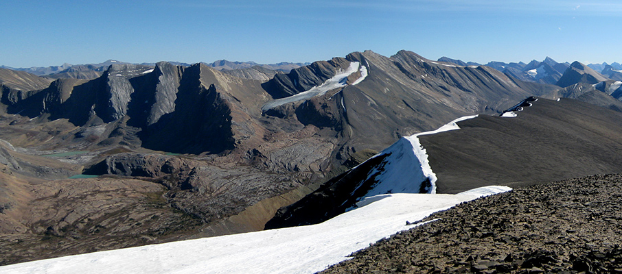
Tangle Ridge itself isn't much to look at from the ascent route; mostly an endless field of scree (that resembles broken dinner plates and is very stable to walk on) once you're above the treeline. However, with each step the view to your left will improve; first with Mt. Kitchener and Mt. Stuttfield and their surrounding glaciers dominating, and then later with Mt. Alberta, Mt. Wooley and Diadem Peak as you near the top. Likewise, the dramatic framing of Wilcox Pass by Mt. Nigel and Mt. Wilcox is always there whenever you take a moment to look behind, with both Mt. Athabasca and Mt. Andromeda becoming more visible as you climb.
Views to the north and east open up once you reach the peak. Looking north provides great views of Sunwapta Peak and the Sunwapta River valley as it flows towards the Athabasca. The view east is intriguing, as almost every mountain as far as the eye can see seems to have an eastward inclination, as though waves of rock were sweeping over the landscape.
Starting in the forests next to Tangle Creek, and then gradually climbing along an alpine ridge to the peak, this trip never quite lives up to the challenge of a proper mountain scramble, but does require a reasonable level of endurance. It took me 7.5 hours to complete the return trip; however, I was nursing a knee injury the entire distance and chose to spend 1.5 hours exploring around the peak, taking photographs. A round-trip time of between 4-6 hours is certainly possible.
Trip Information
Tangle Ridge is accessed from the northern leg of the Wilcox Pass trail. To get to the trailhead, follow the Icefields Parkway 94km south from the town of Jasper, or 7km north from the Columbia Icefield Centre, to the Tangle Falls parking lot. From there, carefully cross the highway and follow the well-defined trail that begins from the road shoulder just to the left of the falls. The trail climbs southward, parallel to the highway for a few hundred metres before it switches back and takes you into the forests next to Tangle Creek.
Roughly 1.5km from the trailhead you will need to leave the Wilcox Pass trail and cross the creek to the left/north. The turning point is very easy to identify; the trail, which travels mostly several metres above the creek, drops to a point that’s almost level with the creek, and there are cairns, a flag marker, and an obvious trail leading to the creek bed to your left. Crossing the creek was a simple affair in September, with narrow, shallow water channels and plenty of rocks around for hopping.
On the opposite side of the creek there’s a rocky delta, where a small stream from Tangle Ridge drains into the creek. This area can be a bit confusing to navigate as there are faint trails and cairns strewn about all over the place; however, know that these all funnel to a well-defined trail that follows the left edge of a gully all the way up beyond the treeline and into the open ridges above. As you near the top of the treeline, take the time to look back at your route a few times; I had trouble finding the exact same path when returning from the peak. However, as long as you remember to aim for that same side of the gully, you shouldn’t have difficulty reconnecting to the main trail on your return.
The path from the treeline to Tangle Peak is very obvious, as you simply follow the ridge that connects the two as it gradually climbs.
Considerations
The upper areas of Tangle Ridge are quite exposed to cold, powerful winds that blow off of the Columbia Icefield. The weather on this particular day was beautifully sunny with an expected high temperature of 26°C (79°F) in the valley; however, by the time I reached the peak I was very happy to have, and to be wearing, a sweater, a hooded soft-shell ski jacket and a pair of gloves. The windchill can be quite significant here. Pack accordingly.
Even in late September, the peak and shoulder areas of the mountain were covered with cornices along the northeastern side. Combined with the steep, perilous drops beneath them, you're best to maintain a safe distance at all times.
Further Reading
Both Kane's Scrambles in the Canadian Rockies and Potter's Ridgewalks in the Canadian Rockies provide descriptions for ascending Tangle Ridge, including details of an alternative descent route that follows the ridge south to Tangle Pass, and then back down to the Wilcox Pass trail.


