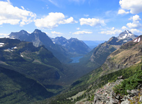
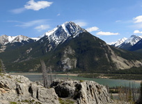
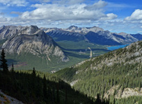
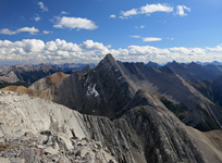
Giant's Gate Logo

Alberta

Despite what media reports might have you believe, there are still many areas within the Province of Alberta that are unspoiled by human industry. The majority of the province's mountainous terrain lies along its southwestern flank, where the spine of the Canadian Rockies follows its course from British Columbia into the northern tip of Jasper National Park, and down south through Waterton Lakes National Park towards the United States.

Reports from this Region

The dramatic view into Glacier National Park from Forum Peak
020
Akamina Ridge & Forum Peak

– Max. Elev. 2,565 m / 8,415ft. –
Hiking / Scrambling

A waterfall along Beauty Creek in Jasper National Park
002
Beauty Creek & Stanley Falls

– Max. Elev. 1,687 m / 5,535ft. –
Hiking

Cinquefoil Mountain from across the Athabasca Valley
008
Cinquefoil Mountain

– Max. Elev. 2,257 m / 7,405ft. –
Scrambling

Crypt Lake in Waterton Lakes National Park
019
Crypt Lake

– Max. Elev. 2,004 m / 6,575ft. –
Hiking

A typical forest scene near Devon, AB
006
Devon Valley

– Max. Elev. 704 m / 2,310ft. –
Hiking

A stunning view of Stelfox, Allstones, Abraham and Abraham Lake from near the basin.
116
Elliot Peak & Sentinel Mountain

– Max. Elev. 2,880 m / 9,449ft. –
Scrambling / Hiking

Geraldine Lakes and Mt. Fryatt
023
Geraldine Peak

– Max. Elev. 2,947 m / 9,669ft. –
Scrambling

The Bow Valley from near the summit of Grotto Mountain
011
Grotto Mountain

– Max. Elev. 2,728 m / 8,950ft. –
Scrambling / Hiking

Mt. Colin from the summit of Hawk Mountain
030
Hawk Mountain

– Max. Elev. 2,553 m / 8,376ft. –
Hiking / Scrambling

The Exshaw area from the summit of Heart Mountain
050
Heart Mountain Circuit

– Max. Elev. 2,319 m / 7,608ft. –
Hiking / Scrambling

014
King Creek Ridge & Mt. Hood

– Max. Elev. 2,420 m / 7,940ft. –
Hiking / Scrambling

Approaching the Falls
021
Lineham Falls

– Max. Elev. 1,985 m / 6,512ft. –
Hiking

Keep Exploring

View other Mountain Regions ›