

Rearguard & Resplendent
The Robson area lives up to its reputation.
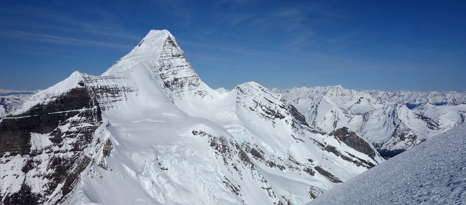
Above: The breathtaking view of Resplendent Mountain from the summit of Rearguard Mountain.
April 8-11, 2016 / minute read( words)
It was while struggling up the last steps of Rearguard Mountain that I felt compelled to turn from the damned scree at my feet to gaze across the vast glaciated valley behind me. The view stopped me in my tracks as the clouds of the day parted enough to afford my first clear view of Resplendent, our primary objective for the weekend. The mountain was massive and remote, a perfect white pyramid with a prominent rock ridge plunging like a ship’s bow through a colossal wall of ice. At that moment, Resplendent was in every way worthy of the name bestowed upon it, and I was happy to have scaled Rearguard’s accursed slope to see it.
I would be even happier the next day as Ben, Vern and I found ourselves standing on Resplendent’s heavily corniced summit, thankful for the flawless conditions we experienced throughout the ascent, and in awe of the sublime views of Mt. Robson and its surrounding peaks.
While the conditions were on our side, there were other struggles to contend with as my feet were in bad shape by the end of the first day. The following 60km of travel wouldn’t be kind, but they say that nothing worthwhile comes easy, and I can’t say anything less than that my first experience of Berg Lake was worth a little suffering.
An Epic Weekend
Berg Lake Approach / Day 1
You know it’s going to be a long day when you look at your GPS unit at an alpine trailhead and see a reading in the 800s – only marginally higher than the prairie cities Ben, and I had departed the night before. But there we were at the Berg Lake trailhead (easily found a km behind the visitor centre just off of the Yellowhead/Hwy 16) at the crack of dawn with ski boots on, heavy packs saddled, and 20km to cover.
It was hoped that we would have a nice ski track to follow all the way in, but the spring melt produced a ridiculous visual of three men skinning from narrow ice patch to ice patch along a dirt trail; as though we were desperately clinging to the last vestiges of winter and deeply in denial of its passing. With every blind corner, fingers were secretly crossed for a healthy covering of continuous white stuff, but these hopes would be dashed until we drew near the famed (but partially frozen) Emperor Falls – roughly 14km later.
Although the route was recorded with a GPS unit, this data should only be used as a SECONDARY navigation tool.
However, before I get ahead of myself, it’s worth imparting the tale of Ben’s curse with Resplendent. Having been repelled twice in the preceding months by dangerous whiteout conditions, Ben was hoping that his third attempt would be the charm. Near the shores of Kinney Lake, an offering was made to the Mountain Gods to allow for our safe passage, the specifics of which Vern and I have been sworn to secrecy, but which may be pried from Ben with a suitable exchange of craft beers and gourmet breakfast staples.
The Berg Lake trail is a very popular tourist trek, so there were few navigational mysteries to contemplate along its length, although it’s worth mentioning that you may want to follow the gravel flats from Kinney Lake to the headwall ascent rather than the high-line trail to the climber’s right at most times of the year.
After 8 hours of toil, we reached the southwestern edge of Berg Lake, and my forefeet were a painful mess. Rubbed completely raw by my grippy insoles, I’d fall well behind Ben and Vern over the last few kilometres to our camping spot in the vicinity of the Hargreaves Shelter, with each step feeling as though I was walking barefoot on gravel. A switch to camp booties and a decent night’s rest would help, but there was still a lot of work to be done.

Rearguard Mountain / Day 2
Roused from our slumber the next day, we quickly ate, packed up and were off into the blackness of a 4:30 am journey to our base camp at the Extinguisher Tower. Our path would follow open floodplains north of Berg Lake to a creek which led us around the northern flanks of Rearguard Mountain, across a frozen lake (which I didn’t realize was a lake until our return), and to the toe of the massive Robson Glacier. There we roped up and carefully made our way up the centre of the first few ramp-like features before drifting to the climber’s left towards a ridge that would lead us to our campsite. As dawn rose and bestowed its incremental light, the darkness lifted and we were treated to impressive views of shattered ice falls and the dominant eastern face of a cloudless Mt. Robson.
At base camp, Vern and I forged the perfect tent pad... with a giant rock in the centre of it, which we would be forced to spoon lovingly later that evening.
With our camp fully established by 7 am, there was plenty of time left to tackle Rearguard Mountain this day. Because of a substantial icefall and crevasse field between Extinguisher and Rearguard, one must travel a significant distance up the Robson Glacier before being able to safely traverse its width to descend towards the lower slopes of Rearguard. While I had felt fine for most of the day to this point, my feet began failing as we crossed the flats of the glacier towards our goal. However, we were already pretty high, and summiting Rearguard Mountain looked less like a scramble and more like a formality at this point. How wrong we were.
Despite abandoning our skis at an elevation of 2,490m with only 260m more to ascend, scaling Rearguard Mountain proved to be a loose, joyless grind. Although proving to be an amazing vantage point for viewing the surrounding region, the three of us were ornery as all hell upon reaching the summit (a milestone one for me, my 150th). It was one of those ascents where you wonder why you’re there and not at the mall, discussing designer watches with posh friends, or sitting around one of those ponds Albertans consider lakes like a “normal person” would (presumably) be doing on a Saturday. Thankfully we each consumed our metaphorical Snickers™ bar, and the happiness and comradery of our merry band began to return after descending to our skis and enjoying some quality turns on the way back to camp under sunny skies.

Resplendent Mountain / Day 3
Ben’s efforts to defeat his curse paid-off as everything came up Milhouse for us on our ascent day of Resplendent. We woke to a clear morning and were treated early in our 20km round-trip journey to a gorgeous sunrise and a mammoth serac fall (from a safe distance away) into the Mousetrap feature on Robson, its resulting snow clouds blanketing an area the size of a city block. The clear skies and great light also allowed us to develop a healthy appreciation of the significant cornicing along Resplendent’s summit ridge and substantial objective hazards surrounding the ascent to the R/R col (which, as per tradition, is only to be spoken of in pirate fashion).
The easy, rolling landscape of the glacier quickly brought us to the base of the R/R col ascent where we knew that we couldn’t tarry before reaching the safety of the headwall’s top, a good 400m above. With some recent avalanche debris illustrating the potential hazard down the centre of our ramp, Ben led a switchbacking route to its left, which kept us out of trouble for the most part aside from a small crevasse we had to step over while traversing a rib midway up the headwall.
Having spent the past two days surrounded by a sea of white we were treated to a sudden rush of green upon reaching the R/R col, where the views to the west open up and the verdant valleys of Robson Provincial Park sprawl out below you towards the Town of Valemount, and the ocean of peaks that lie beyond. Having made good time to this point, we took a solid break and transitioned from our skis to our cramponed boots to tackle the summit ridge.
Although the top looked near at this point, Vern cautioned that there was still much work to do and he was right. The summit was another 460m above us, and as Ben led us to the crest of one horizon after another, the mountain kept on going. Because of the cornicing, we stuck well to the climber’s right of the ridge crest, finding our steps well supported by the snow on the west face. Thanks to this supportive snow, the growing exposure to our left never became that pressing of a concern.
Soon enough we reached the summit of the mountain, staying clear of the absolute highpoint with the belief that it would be entirely cornice, a reasonable safety measure. Unfortunately, it did come with the consequence of not being able to see the southeastern summit views towards the giants of Jasper National Park. However, we did have perfect views in all other directions, and particularly towards Mt. Robson. We even remarked at that moment that our entire ascent had been under windless conditions, a truly unexpected bonus.
Speaking of having things coming up Milhouse, I found out during this day that it was travelling on flats that was aggravating my feet, and that (for whatever reason - perhaps more weight transfer to my heels) I was fine on ascents. It was a huge relief to make it all the way up Resplendent feeling strong. Not even the altitude was bothering me.
With the sun beginning to blaze we quickly wrapped-up our summit celebrations, wanting to complete the ski descent from the col to the Robson Glacier before solar heating could unleash mischief. Having not skied much this past winter, and never before with a heavy pack (I had the rope at this point), I was a little nervous about this descent, and it didn’t help that my first few turns were akin to Bambi on ice. Thankfully there was some more mellow terrain to work out my balance before we dropped into the col, and the snow conditions below the col were just about perfect at this point of the day. If you’re going to ski dangerous terrain, it’s nice to do so stylishly, and it felt good to ski that line well and then enjoy the mellow run back to our base camp at Extinguisher.
After a well-deserved lunch break, we packed up and began the return to our camping spot in the vicinity of the Hargreaves Shelter. Unfortunately, things ceased their coming up Milhouse by the time we reached the now suspiciously thawing lake at the toe of the Robson Glacier and, between my ruined feet and the punishing heat of a blazing sun, I struggled mightily to reach camp.
The Death March / Day 4
Share this report on:
I was pretty anxious about the 20km return trip to the trailhead given my feet, even offering to leave well in advance of Ben and Vern. I did my best to tape them up ahead of our departure, and for a while, it seemed like the approach was going to work, with the ski descent past Emperor Falls and then the boot packing to the Whitehorn Shelter passing without incident. However, these efforts had only bought me time, and upon reaching the Kinney Lake, every step was heralding the mounting depth of injury.
If I could have called upon a Nascar-style pit stop to equip a new shoulder blade and feet at that juncture, the remainder of the return would have been a non-event. Alas, bound to the finite endurance of my corporeal body I was forced to retreat deep inside and grind my way those last 6km to the parking lot. There, relieved of my heavy pack and villainous ski boots, life began to improve considerably with delicious pizza to look forward to in Jasper, and an unforgettable trip to the Robson area to look back upon from the comfort of the passenger seat.


")


")


 on Resplendent")
")


