Alpland Peak
A little bit of everything, all of it memorable.
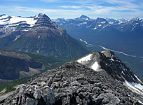
Above: Gazing past Opal Peak (centre left) towards the Maligne Lake region from Alpland's summit.
September 24, 2016 / minute read( words)
Ever since I ascended Opal Peak I've been highly motivated to do some explorations in the valley to its east; having been awed by its picturesque lake, moon-like karst, and an array of beautifully sharp peaks from a distance. Somehow, through the conspiring forces of conditions, climbing partners, forest fires (one at Medicine Lake), and work commitments, there would be a four-year delay in action on those sentiments. However, as my first adventuring into the valley shows, I was definitely onto something.
As I wound my way along the excellent, but unofficial, trail to Surprise Lake from the Maligne Lake Road I was struck by the distinctive triangular summit of a mountain near the centre of an impassable rock ridge which flanks the entire eastern side of the valley. “Alpland Peak”, as I've named it, reigns over the Alpland Creek watershed to the east, which in turn flows into the Rocky River and then on to the Athabasca. While one could perhaps refer to it as Surprise Peak in reference to the better-known lake at its western feet, that name didn't feel right for the straightforward nature of the climb (I was able to pick out two routes from several kilometres away) and its classic mountain profile. In reality, the only surprise of the day on this mountain was an existing (not to mention giant) summit cairn.
Those seeking a beautiful hike with an easy scramble to breathtaking views at its conclusion will be hard-pressed to find many better options within Jasper National Park that are this accessible, yet can almost assuredly promise solitude. Highly recommended!
Routefinding
The Mystery Trailhead
The crux of an ascent of Alpland Peak or even a hike to Surprise Lake is locating the trailhead. I had studied the topographic map closely and spoke to a Jasperite friend who'd been to the lake for details and left for the park with a very clear idea of where I was going. This wasn't enough. After driving the suspect area a few kilometres south of Medicine Lake, searching the forest fruitlessly, and then flagging down a Parks employee who helped narrow the search further, it still took another 30 minutes of probing before I finally came across a promising trail. As it turned out, the 100 most obscure metres of this trail are (paradoxically) those leading from the road. I highly recommend taking my GPS track along as a reference for this part.
Although the route was recorded with a GPS unit, this data should only be used as a SECONDARY navigation tool.
However, if you can't make use of a GPS track you will need to note that there is no sign, no pull-out, no obvious dirt trail, and my 2-foot high cairn likely didn't survive beyond the evening it was built. In the absence of such wayfinding aids, I suggest taking a close look at photos 1 and 2 and noting the following hints. About 2-3km past Medicine Lake the Maligne Lake Road goes through an S-shaped turn while visibly passing a bend in the Maligne River. Shortly after this sequence, you'll see a huge grey boulder (photo 1) on the right side of the road across from an open slope. Slow down when you reach it. Now, watch closely along the left side of the road for a pair of similar, but smaller boulders (photo 1). You will find the trail a few metres to the right (south) of those rocks (photo 2). Note that you can switch the map above to a street view by dragging the yellow person icon to further explore the trailhead area and get a feel for it before you leave home.
Finally Underway
The first section is fairly unremarkable as you follow a solid forest trail that gently ascends from the Maligne Valley to the higher valley to its east; however, pleasant views of the upper alpine soon becomes the norm. At the 2.5km mark you'll reach an area that immediately struck me as a perfect ambush zone; a big round meadow with chest high shrubs and an alluring trail that passes right through the centre (photo 5). Don't be lulled into this trap, the way to go here is to follow the easy open grass to your left that skirts the periphery of the meadow and rejoins a dirt forest trail at the far end. After a few hundred metres you'll find yourself at the next distinctive phase of the valley trail.
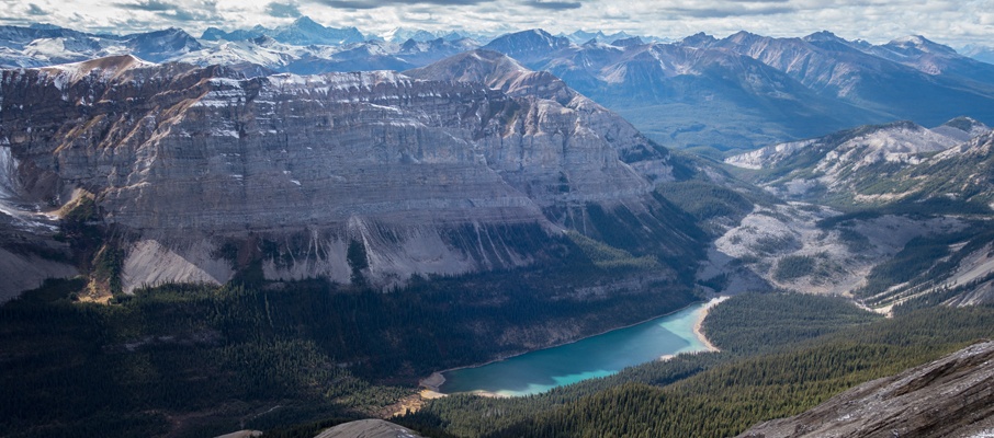
At some point a massive rockslide ripped through the valley from the eastern ridgeline, covering several square kilometres with boulders. The origin point's pretty easy to guess at, as you can spot a section of the ridge that visibly thins into a confluence of perfectly straight edges and flat faces where perhaps hundreds of vertical metres of material lost purchase and slipped away (photo 10). The damming effect of all this rock likely ended the draining of this valley into the Maligne River and created Surprise Lake. From this point of the trail to the sandy shores of that lake, you'll be following the legacy of this cataclysmic event. The key is to stick to its edge.

After that last forest section the trail takes a sharp turn to the right and from here on you don't want to drift into either the forest or the boulders. Soon after heading right the trail will take another sharp turn to the left and becomes vague as you pass through a very mossy section. I made the mistake of thinking that the grass trail had ended, and began a very long boulder-hopping adventure to the lake. While this gave me some great photography viewpoints above the lake, if you're not purposely looking to suffer for your art, stick to the trail by walking through the moss. When the trail decides to begin crossing the boulder field, it does so obviously, easily, and for a short duration before returning you to a nice grassy trail that descends to a (then) dry creek bed, which in turn leads you directly to the lake.
No Surprises
During the approach, I had guessed that both the first of Alpland's western ridges (the lower one which ends mid-mountain) combined with a direct line up the western face and its higher, southwestern skyline ridge would “go” as scrambles, and I would be proven right. I skirted around the left (eastern) side of Surprise Lake, which was easily done for the most part except for a five metre section of rock where some careful work was needed to avoid falling into the lake, or bushwhacking beside it (note: September is a very dry time of the year, so your experiences with this section could vary considerably). Soon I was past the lake and began following a drainage into the pine trees to start the ascent of Alpland's mid-mountain ridge.
As I ascended, the drainage soon turned into more of a smooth, slab chute and I chose to bail into the lightly treed hillside on the left to bypass it. This hillside was steep and kind of crappy, and I was soon gazing longingly at the right side of the drainage, which looked mellower and seemingly offered a series of nice gaps between its trees. This could entirely be the case of the grass always looking greener on the other side, but I would suggest venturing that way when in the area. Once reasonably past the chute, I returned to the drainage, and from there I easily climbed an open grass slope to the ridge crest which I then followed to Alpland's western face.
At the western face, I found a narrow ramp to the climber's right which leads to a traverse above a high cliff band. The exposure here was pretty mild, and would only present a safety concern with the presence of snow or ice. Once crossed, I found myself at a broad scree slope that, by trending upwards to the climber's right, led me all the way to Alpland's summit.
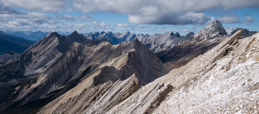
Given the “Fight Club” nature of scrambles in Jasper and the absence of a register, it's difficult to tell how many people had ever stood atop this summit before me. At the very least, one group had, and based on the size of the cairn they built, they did so with plenty of spare time on their hands. The views from the summit, and frankly, from mid-mountain onwards on both routes, were fantastic. Whether eyeing the emerald Surprise Lake and its intriguing valley, the dramatic and glaciated upper Maligne Lake region, the countless jagged peaks in the Queen Elizabeth Range and South Boundary regions, or elsewhere, the viewer's rewarded for their attentions. I shot a ton of photos and seeing that it was getting quite late in the afternoon, packed up and began my descent.
Yet Misadventure Awaits!
Seeing that the southwestern ridge was pretty mellow I headed in that direction (skier's left) from the summit and soon gained a lower high point overlooking the lake. From there, a lovely scree run allowed me to quickly drop 450m into a drainage which I followed for a short distance. When the drainage started to become a bit slabby, I gained the hillside to the right and began making my way down those easy slopes towards the valley floor.
Midway down this slope, I felt a sudden, sharp pain in my right leg as something gave out near the knee. My immediate fear was that I had re-injured my LCL (originally from running), but it would later be diagnosed as an overuse injury to my Iliotibial (IT) Band. Regardless, I was a good 9km from the road with hours of limping and crutching to look forward to as darkness crept across the valley. Awesome. I took a break, consumed some Advil to control the inflammation, and then made my way to the valley floor.
Aside from its unfortunate leg-exploding nature, the only downside to this descent line is that it requires about 800m of mild bushwhacking to return to the lake. After following a dry creek bed through some pine trees, and a few acres of waist-high shrubbery, I was back at the lake and retracing my steps around it to the far side. Having seen a better line from my earlier boulder-hopping adventures earlier, I began following the dry creek bed away from the lake on the northern side. I was beginning to zone-out as one does on a deproach when something caught my eye.
Now, I know that bears are known to be fast and have even seen the odd YouTube video of one pursuing a cyclist; however, you don't really know until you see the biggest goddamn grizzly that you've ever seen take off like Seabiscuit with the Triple Crown on the line. Thankfully, the furry rocket blazed a perpendicular trail into the forest and was quickly out of sight.
It seemed inconceivable that I could strike terror into a creature of that size, so my mind raced to find an alternative explanation. In the absence of a firestorm raging through the opposite forest, my mind settled on the possibility of an even bigger bear. Perhaps a polar bear had ranged southward to the Rockies for a vacation and had sparked a territorial war? It seemed much more plausible. I decided to bypass the creek/trail junction ahead by climbing into the boulders to my left, hoping to keep some awkward terrain between me and the return of either bear.
Share this report on:
Once I felt safely distant from the bear danger zone I returned to the trail and found that it offered a much easier line through the boulders than the one I had forged on my own. However, my joy at this development was short lived as I soon heard a distant yell to my left. It was clearly a man's voice, the yell was about 3-4 words in length, but the words themselves were indistinct. And it never repeated. I stopped dead in my tracks. Listened. Waited. Called out twice. Climbed to get a more commanding view of the boulder field. Waited. Called. And it never repeated. There was no wind in the valley, and everything had become deathly quiet. To the west, the sun dropped further behind the indifference of a mountain ridge. I was alone.
I continued along the trail by headlamp, past the mossy point where I had mistakenly abandoned the trail in the morning, and back to the road where no other vehicles were parked. While I had seen no other sign of recent human travel (beyond my own) on the return, a large bull moose sat by the road watching me, knowingly, as I left.
")


 pass within the Opal Hills")
 and Sorrow (R)")