

Nigel Peak
An essential Columbia Icefields scramble
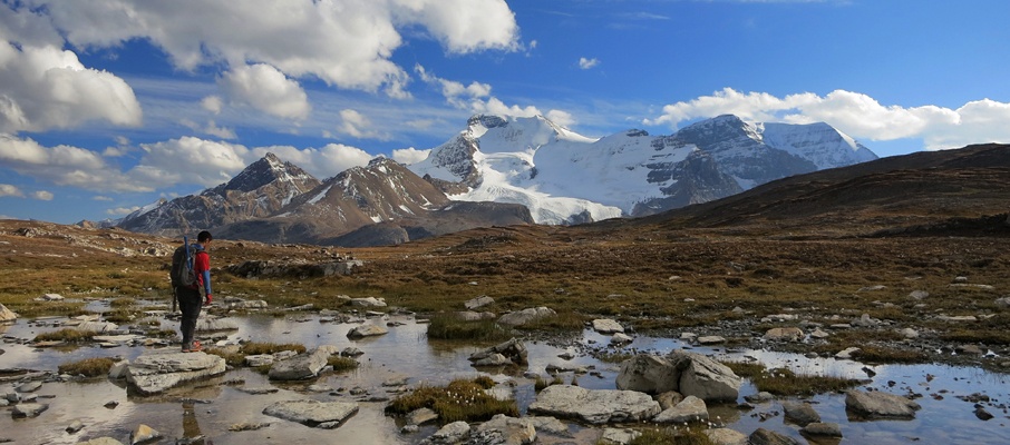
Above: Nigel Peak's summit views over the Columbia Icefields and the Athabasca Glacier are stunning.
September 14, 2012 / minute read( words)
During one of my very first scrambles up Tangle Ridge I was blown away by the incredible view it offered of Nigel Peak and Mt. Wilcox, vowing that I would return to ascend those mountains in the future. After thinking about Nigel often during the year and always keeping it high on my “list”, I found myself at the base of the mountain with three friends on a perfect fall day. Well, nearly perfect. Illness would soon claim two members of our party, leaving only Viet and me to summit the mountain. Months later I still feel bad for them, as this was one of the best days I’ve enjoyed in the Rockies.
On a good day, the views from the 3,219m summit of Nigel Peak are genuinely incredible* and are said to be some of the best available in the region without taking on the challenges of mountaineering. However, that reputation can be misleading, as the conditions on Nigel can quickly turn a moderate scramble into a genuine mountaineering ascent, as Viet and I found out as we were forced to ascend the last steep pitches of the glacier with well-planted crampons and ice axes.
* The views, particularly of Mt. Athabasca, were so continuously epic this day that Viet would return within the week (with a hired guide in tow) as he had to climb that mountain. I completed the same trip, driven by a similar compulsion, back in July.
Routefinding
An ascent of Nigel Peak begins at the Wilcox Campground a few kilometres to the south of the Icefields Centre on Highway 93 (Icefields Parkway). You'll find a small parking lot near the turnoff with washrooms and a signed trailhead for Wilcox Pass, which will bring you most of the way to the base of Nigel Peak.
Although the route was recorded with a GPS unit, this data should only be used as a SECONDARY navigation tool.
Following the trail from the campground will see you quickly ascend through a forest before reaching an open ridge that parallels the highway. After taking in the impressive views of the Athabasca Glacier and its surrounding peaks, the trail will take a sharp turn to the right (east) up a deep gully. It's around here, about 1.8km in from the trailhead, that you'll want to leave the Wilcox Pass Trail and begin making your way directly across the meadows to the scree slopes of Nigel.
Nigel's west ridge travels in a straight northwest/southeast line along Wilcox Pass before curving back towards the main summit, and it's on this curve that you will want to begin your ascent. There are two broad slopes, separated by a rocky rib, that can be ascended. There probably isn't a better choice to make here, as they're both slogs on loose scree and debris.
Viet and I chose to take the left slope while sticking close to the centre rib climber's right for most of the ascent while drifting to a climbable rib 2/3s of the way up if for no other purpose than variety. After a lengthy battle, we topped out on the ridge and were rewarded with our first views of Wilcox Lake and the route to the summit (see image #5). At first, it looked like we might get cliffed out trying to get from the left ascent slope to the other, but we soon found an easy way down once we passed over a small highpoint. From there we followed a visible trail over another highpoint, a rock hard snowfield, and then diagonally up the main part of the mountain on compacted scree.

Many of the resources I consulted while researching this trip alluded to the possible danger of an uncontrolled slide down Nigel's summit glacier into Wilcox Lake, hundreds of metres below. This danger, as I discovered, is a bit of an exaggeration. While there is a dangerously steep section to the glacier that would send you rocketing off a tall cliff band (see image #46), there's no way you'd ever make it to Wilcox Lake.
The better discovery is that you shouldn't come anywhere close to that section of the glacier. As you're making your way diagonally up towards Nigel's shoulder, the trail will eventually bring you to a cliff band directly beneath the shoulder. The key here is to scramble that cliff band at your earliest convenience to gain the shoulder. The scrambling is easy in sections here, but you may be tempted to traverse to the climber's left where the cliff band can be bypassed. However, that will lead you towards to the dangerous part of the glacier.
Once on the shoulder, I made my next two discoveries of the ascent. The first is that the path from the shoulder to the summit is terraced, which is great from a safety standpoint as each of the three rises has a clean run-out that will stop you. The second is that you cannot depend on there being a scree route to the summit. Most reports I had read mentioned that the Nigel glacier recedes enough over the summer to provide scree route along the western edge (or climber's right) of the summit ridge, allowing the choice between a scree or snow ascent. However, 2012 was one of the heaviest snowpack years in decades, and there was the only glacier to ascend.

With our ice axes in hand, Viet and I carefully walked up the first two snowy slopes before reaching the steepest of the three, just below Nigel's summit. This slope had a few centimetres of rock hard snow over ice and would have been impossible to ascend without crampons and an ice axe (although a pair of ice tools would have been even better). With all our pointy gear in use, we carefully made our way up the slope (see image #39) and were rewarded with beautiful views in every direction from the summit cairn.
On the return, we front-pointed a third of the way down the slope until we were clear of some rocks and then safely glissaded down to the terrace below, where we removed our crampons and continued the descent. We downclimbed to the diagonal trail and then followed it about halfway down before plunge-stepping down a scree slope to the skier's right to take an alternative return route via Wilcox Lake. The routefinding is straightforward here, but be aware that the snowfield between Nigel Peak and its western ridge can be a dozen or more feet deep, and had a lot of holes the further we descended.
Share this report on:
From the lake, continue on a northwesterly direction while avoiding the temptation to shortcut over the ridge early. The drop on the other side of the crest is vertical, so you're better off being patient and sticking to the plateau all the way back to Wilcox Pass. Once you're back on the pass, begin heading southward and look for the trail. Following this trial on a southeasterly heading will bring you back to the trailhead with the bonus of thrilling views the entire way.
Further Reading
Alan Kane provides a detailed description of the ascent of Nigel Peak in Scrambles in the Canadian Rockies (pg. 307). His illustrated ascent route matches what's described in my report.


")


")


")


")


")

")
")


")


