Akamina Ridge & Forum Peak
Update in progress...
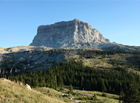
Above: The striking view from Forum Peak across the border towards Kintla Lake in neighbouring Glacier National Park
August 11, 2012 / minute read( words)
Akamina Ridge is simply a spectacular hike and an absolute must-do for anyone visiting Waterton who's capable of completing its 22km circuit. The trip can be explained in twos as it traverses two countries (Canada and the United States), two provinces (Alberta and British Columbia), two incredible walled lakes (Forum and Wall), and two named summits (Forum Peak and Akamina Ridge); all the while providing dramatic views into two national parks (Waterton in Canada and Glacier National Park in the States). However, I'm guessing that the photos are the only explanation anyone would require to justify a journey here.
A hike of Akamina Ridge along with a highly-recommended side-trip to nearby Forum Peak (a straight walk-up reached by following a connecting ridge) does make for a fairly long day. You'll want good weather for the trip, not only for the spectacular views available in all directions, but also because you'll be spending several hours on an open, shelterless alpine ridge. It should also be noted that there are a pair of rock bands along the main ascent ridge between Forum and Wall Lakes that must be scrambled; however, the scrambling terrain here is quite easy and shouldn't turn back anyone capable of climbing a slightly offset ladder.
Unsurprisingly, Akamina Ridge is a fairly popular hike in the region. However, unlike the ridiculous mass of humanity we encountered at Crypt Lake the day before, we only encountered 15 other hikers on a beautiful and sunny, Saturday in August. Spread over 22km of trail, encounters with these other hikers (who were often travelling in the opposite direction) were infrequent and never gave the place a feeling of being busy.
Routefinding
To access the Akamina Ridge area follow the Akamina Parkway west from the Waterton village for roughly 12km to the trailhead for Akamina Pass. An easy trail will lead you uphill for 2.2km, first past the Alberta/British Columbia border, and then to a major fork in the trail at Akamina Pass.
Although the route was recorded with a GPS unit, this data should only be used as a SECONDARY navigation tool.
Akamina Ridge is a loop trail from this point, so you can head in either direction. However, I strongly recommend taking the left trail to complete the loop in a clockwise direction for the following reasons:
-
Going clockwise will allow you to climb rather than downclimb the scrambling section. It may seem counter-intuitive at first, but in scrambling, the ability to see your entire route and visually inspect each potential hold before committing a hand or foot to it usually makes an ascent easier than a descent of the same terrain. This route will also get the steep climb of the day out of the way early, allowing you to enjoy the more gradual descent to Wall Lake later when you may start feeling the strain of many kilometres travelled.
-
Going clockwise provides the most useful lighting, as the sun will either be above or behind you for the majority of the trip.
-
For the most part, the best views along this trip will be to the southwest of your position. Travelling clockwise will have you doing the majority of the ridge along a westerly course, saving you from having to turn constantly to take in the views.
Assuming you've followed the above advice and have taken the left trail, you should soon arrive at a warden station after a short downhill walk from the pass. From here the trail continues to the left (southeast) where you'll soon reach a junction with one path leading to Forum Lake, the other Forum Falls. As the falls are only 100m away to the right, it's well worth the side-trip. Once you're done there, return to the junction and continue upwards along the path towards Forum Lake. You'll reach a boggy area with a boardwalk and a wide assortment of wildflowers shortly before arriving at the lake.
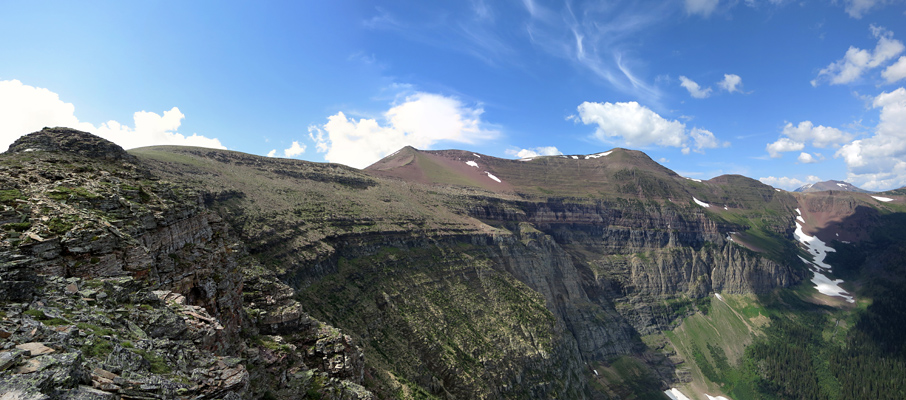
From the shore of the lake, the trail heads to right (west) towards a low ridge that separates the Forum Lake and Wall Lake areas. After negotiating the switchbacks to the ridge, it pays to walk the few metres to the other side to get your first views of Wall Lake and the summit of Akamina Ridge. The trail then contours along the right side of the ridge following a rock band before the slope opens up and the path the climbs steeply upward on surprisingly loose terrain. The top of this slope is where the scrambling portion begins.
Thanks to their regular use, the scrambling routes through these rock bands should be reasonably obvious and are easier to negotiate than the loose material that covers most the hiking sections of this ridge. After making it through a few rocky steps of about 2-3m in height, you'll top out on the ascent ridge and find yourself hiking to a higher ridge which links Forum Peak with Akamina.
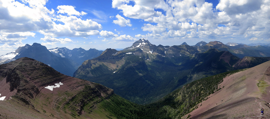
From this point, I highly recommend taking the side-trip to your left towards Forum Peak. It's purely a hike to the summit, and the round-trip will only add about 2km of walking to your day. Why should you do this? Aside from being able to claim that you summited two named peaks, Forum is an excellent scenic lookout for Cameron Lake, Mt. Alderson and Mt. Carthew in Waterton, and offers the best views of the day into the Kintla Lake Valley in Glacier National Park. You'll find three large cairns on the summit ridge, each one perhaps indicating the highest point in Alberta, British Columbia, and the United States; as the borders of all three jurisdictions meet at this mountain. The middle of the three cairns is the highest point and the official summit of Forum Peak at 2,425m / 7,956 ft. There was a registry that Rabin and I signed, but it was in bad shape at the time and needed replacement.
The long and highly enjoyable ridgewalk across Akamina Ridge is very straight forward as you only need to follow the well-established path. The first and third highpoints can be bypassed by following paths which diverge to the climber's left, while the second highpoint is the true summit of Akamina Ridge at 2,565m / 8,415 ft. Unlike Forum Peak, the summit cairn here is one of the laziest I've ever seen (it could barely be considered a rock pile). However, as I was feeling equally lazy after 11.5km of hiking and 1,257m of accumulated elevation gain, I did nothing to rectify the issue.
Beyond the main section of Akamina Ridge, the trail turns north for a kilometre beyond some very colourful mineral bands towards Bennett Pass, and the easy trail which gradually lowers you through mostly open meadows towards Wall Lake. Once we reached Wall Lake, we contoured around the lake to its northeast end past a surprising amount avalanche damage (which had thankfully been cleared from the trail) and then began the 3km hike through the forest to the Akamina Creek campground.
From there we followed the Creek Trail east for a short period before arriving at the Akamina Pass junction, which marked the end of the loop. All that was left was the 2.2km walk back to the trailhead before a return to Waterton for celebratory ice cream and a rather refreshing swim in Waterton Lake.

Considerations
Share this report on:
Akamina Ridge is a fairly long day trip that takes about 7-10 hours to complete depending on the pace of your group. I had 2 litres of water with me, which is probably the minimum you'll want to carry in with you. For those with filters, there are several streams where you can replenish your supply. However, keep in mind that those sources are quite scarce above Forum or Wall Lakes, and non-existent along the ridge.
Shelter is another non-existent commodity up on the ridge. It's a good idea to have rain gear and additional clothing to wear should the weather change on you during the long 7km traverse (which includes Forum Peak) on open, exposed terrain. Waterton has a reputation for having strong winds, which could make things surprisingly cool even on an otherwise hot day.


")


")


")

")


")


")
, Thunderbird (centre) and Vulture Peaks (right)")
")
 to Akamina's Summit (right)")


")

 to Long Knife Peak (USA)")


")


")


")