

 August-10-2012
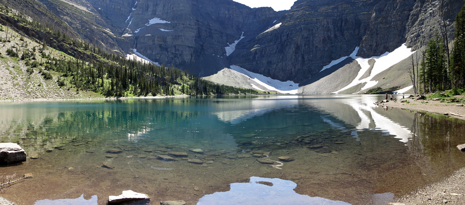
 Crypt Lake is an intriguing hike in Waterton National Park that offers a surprising amount of variety, along with a healthy dose of novelty. Starting with a boat ride across Upper Waterton Lake, the trial begins in heavy forest and then weaves its way along an alpine valley passing a canyon and dozens of waterfalls, including the huge Crypt Falls, before climbing a headwall below Crypt Lake. Ascending the headwall requires passage through a natural tunnel, complete with a ladder section, before a last short section of hiking brings you to the middle of the cirque where Crypt Lake straddles the Canada/US border.
However, despite these many positives Crypt Lake can be a little “oversold”, in both senses of the word. Posters around town promote Crypt Lake as the best hike in Canada; this is patently absurd. It's a great hike, very scenic, and certainly worth the time when visiting the area, but it's not even the best hike in Waterton (see Akamina Ridge for example).
Worse though is that “oversold” can be a very literal issue depending on when you attempt this hike. A trip report I had read ahead of time gave me the impression that the boat crossing was on a water taxi-type vessel with maybe up to 10 people; which would be nothing on a trail of this size. This may be the case during the spring/fall shoulder seasons, but mid-August, we were on a vessel carrying over 110 people. That's 110+ people arriving at the exact same trailhead at the exact same moment, as though we were re-creating the beach landing on Normandy.
I've never experienced gridlock before on a hiking trail, and it took us over 4km to overtake enough people so that we could finally set our own walking pace. If I come across as somewhat ambivalent about Crypt Lake, this is why. Neither Lake Louise nor Maligne Canyon can match this level of ridiculousness, even on a peak day. If you see a big crowd forming at the docks in Waterton, be sure to pick one of the many other great hikes available in the park.
Trip Information
Your trip will begin at either 9:00 or 10:00 am in the morning at the Waterton Marina, which can be found in the centre of Waterton just north of the Bayshore Inn. To buy a ticket for the boat crossing, head for the variety-type store at the far (north) end of the marina building (they cost $20 at the time of this write-up). Once you're on the boat, it only takes about 10-15 minutes to complete the crossing of the lake and then unload on the other side.
The route to Crypt Lake and back is well-signed and maintained to tourist standards, so there really isn't much that needs describing, except for two major points. As part of their overview of the Crypt Lake hike, the tourism company frames Hell-Roaring Canyon (HRC) as a side-trip that you should only risk if you have the time; and given that everyone is concerned about making it to the lake and back in time for one of the limited return trips, this bit of discouragement ensures that almost no one takes that path in either direction. Out of the 110+ people who visited Crypt Lake this day, Radka, Rabin and myself may have been the only people to see the canyon; and Radka and Rabin were so transfixed on catching the first boat back that I may have been the only one to stop for photos!
Which is both unfortunate, and ridiculous.
My suggestion is to take the Hell-Roaring Canyon route in both directions for this hike, and for a number of reasons:
-
The standard trail is absolutely viewless between the part where the HRC route branches off the main trail, minutes away from the dock area, to where it rejoins near Twin Falls, 2.6km later. Meanwhile, the HRC route follows a canyon that is similar in many ways to Maligne Canyon or Beauty Creek, although not quite as scenic. You'll also get some nice views of Hell-Roaring Falls and many nearby mountains. Sure sounds better than seeing nothing except for the backpack in front of you and dense forest for an hour or more, doesn't it?
-
Doing this route in both directions will only add an extra 800m to your trip. At a reasonable walking pace of 4 kph, that's only an extra 20 minutes of walking. Well worth it for the improved views!
-
Due to the discouragement of the tourism company, nobody follows this trail. This means you can set your own pace, stop to take photos without fear of losing your “spot” in the herd, and, even with the additional distance, still overtake the majority of the hikers present by the time you rejoin the main trail at the junction.
The only downside to the HRC trail is that it was built about 5-10m too high above the canyon. You'll probably find that you need to climb down the hill a few metres to get a decent view of what's there and, from what I remember, it was usually quite safe to do so.
My other suggestion is to not use the steel cable that's provided as a railing along the exposed ledge one must traverse after the tunnel. There's a fair amount of give to the cable and, with multiple people around, the height at which the tension stops it from dropping under load can vary by a foot or more with each step. This inconsistency can easily throw you off balance at a very inopportune location, especially when descending. I would recommend using the regular supply of excellent hand holds offered by the rock along the ledge; the rock's solid, and isn't going to move no matter what other hikers may be doing nearby.
Considerations
If you somehow manage to miss both return boat crossings, you won't necessarily be stuck there for the night, or faced with a chilly 1km swim across Upper Waterton Lake. However, you will face a long 14km hike back to Hwy 6, from which you will then need to hitchhike back to town. To reach the highway, follow a trail north along the shore from the Crypt Landing dock area that eventually becomes the Wishbone Trail. This trail will lead you on a northeasterly course past both Upper and Lower Waterton Lakes before reaching the highway.
The GemTrek topographic map for Waterton shows both this escape route, and many other hiking possibilities quite well. It's worth the $10 investment and shouldn't be too difficult to track down in town, or at any decent outdoor shop in Alberta.


")


 and Mt. Richards (Canada)")